|
|
|
|
Page Quality:  (19 votes, 2296 hits) -- Rate This Page | View Votes/Comments (19 votes, 2296 hits) -- Rate This Page | View Votes/Comments |
| If you have some
info that could help to improve this page, click on the "Add
Info" link next to the appropriate section below. |
|
|
*****AND IT IS UNDER VERY HEAVY CONSTRUCTION RIGHT NOW:
AFTER PASTING THE GENERAL CHAPTERS AND THE 117 MOUNTAINS, THE
GROUPS, THE CAMPS AND THE BETTER PART OF THE MAJOR GROUPS, IT WAS
DAZZLING BEFORE MY EYES, IT MIGHT TAKE ME MONTHS, (MORE LIKELY EVEN
YEARS), TO MAKE THIS PAGE IN WHAT I WANT IT TO BE
EVENTUALLY*****

Despite the fact that it will already make it easily one of
the biggest SP mountain pages, the information I will put up at the
starting of the page, is only a beginning. This page is meant to be
under continuous construction for the coming years. So it is a
framework, by far not finished, and it probably will never be really
finished. New information will be added continuously and I hope I
will get some help from others in this also. If you go to the Bogda
and discover new lines, convenient walk in routes, nice camp spots
or anything else, please add a comment at the concerned chapter and
I will intergrate it as soon as I notice.
This page is
meant to be a sort of brief guide book to the Bogda Shan: Up to now
none was in existance and the work I have been doing on this
material I consider a first step in lateron producing and publishing
a fully fledged guide book to the Bogda Shan. What does it contain?
1) For certain the usual information that is to be
found on all decent mountain pages on Summitpost: How to get
there, Camping possibilities, Red tape, conditions and so on.
2) Information about the 23 major access ways into
the mountains which together can bring you to all of the 18 major
distinctive groups containing 4000+ mountains. These are called
gullies in the Bogda. You will be informed about where they are to
be found, where you would have to start up them, how long they
stretch, which mountain groups they give access to and so on.
4) Information about 21 convenient base camp spots in
the Bogda and Dabanshan from where all 113 described mountains can
be climbed. The Upper Sangecha Camp spot is meant to be the future
location of our Mountaineering hut.
5) Description of the
19 distinctive groups of mountains of Bogda Shan where peaks
of over 4000 meter are to be found. Summing up of the peaks located
in the specific ranges
6) A seperate Chapter for each of the
113 peaks that are higher than 4000 meter, with information
about height, position, difficulty of easiest route, how to get
there, climbing history and more.
7) A seperate chapter for
each of the 83 major glaciers of the bogda shan with info
about their length, surface area, position, peaks that feed the
glacier and so on.
It is a dream of
mine to in the future put up seperate mountain pages of most or even
all Bogda Shan mountains. But.........that is fated to remain a
dream for a long time! With my busy daily job, time for working on
my summitpost pages is anyway very limited. To that comes that for
the coming half year I have material to work on for at least 30
mountain pages of peaks in other Xinjiang and Tibet mountain ranges.
However, I think the information about routes contained in
the chapters on the individual mountains on this page is by far to
limited to get started with. As I know the Bogda range intrinsically
by now, I however have the knowledge for route descriptions on most
of the peaks. As a route page costs me much less time to construct
in comparison with a fully fledged mountain page with routes on it,
I have decided to put up detailed route information of routes on a
whole set of Bogda Shan mountains on this page for the time of
being.
However, creating a hundred and something route pages
is quite a job in itself: Even if i put up one a day it will take me
months to complete this work. So be patient. If there are any
questions concerning the climbing on peaks of which not yet a route
is on, you can always contact me directly and I will answer you in
detail as soon as I can.
This page will
consist of over 200 chapters, and I am well aware that this will
make for tough reading. To keep such a "book" interesting to plough
through Photographs are essential and the page will need several
hundred photographs in the end. However even the potential of all
the Urumqi summitposter, most of which are close friends of mine, is
limited and in order to put together a comprehensive set of
photographs a Mont Blanc size pile of work has to be done: Going
through our respective archives, selecting good pictures, attaching
them to the right chapters and above all going out into the Bogda to
obtain what we not already have, and that is the majority! To start
with this page will not have more photographs than the average size
mountain page, but in time more and more will come up. Hope you
understand that I can't built Rome in one day.
( More "Photographs" photos/images | All Bogda Shan Mountain Group photos/images )
I would have
been never, ever able to gather all the information I needed on my
own, and I am very grateful that I had the help of a great number of
men with intrisicate knowledge of the Bogda mountains credits
go out to:
- Hu
Fung Ling.
- John
Shen.
- Lao
Zhao Ziyung. (That his soul may have peace in the realms of the
mountain god now.......)
- Aree.
- Frank
Graaf.
- Bob
Keaty.
- Kafir
Chen. (The majority of the photographs on this page have been
made by him)
- Wang & Wang of "The North Goat" outdoor
equipment store Urumqi,
- All at "No4 Sheep Pen Bar", the
climbers hangout of Urumqi
- Yuan Guoying, chairman of the
Xinjiang ecological society
- Li Wi Dong of the Zoological
Department of the China Academy of sciences.
- Ester Bauman, for
ananlysing the satelite pictures
- Atla Abdulin, for keeping me
going on with the work
- the People's Liberation Army, for
providing me with the staff maps.
- Mi Desheng, cartographer of
the Lanzhou Institute of Glaciology
- Kong Baocun, of Kashgar
Silk Road Expedition Services
- All those I forgot to mention
here
 |
 |
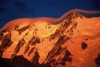
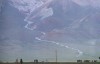
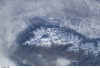
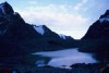
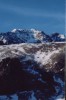
The Bogda Shan
belongs to those places on earth that has been very well covered in
satelite photography. I did not want to withhold you some pictures
that show the huge contrast between the bleak desert plains and
majestic Bogda towering almost 5 kilometer above them.
 ( More "Bogda Shan from Outer Space" photos/images
| All Bogda Shan Mountain Group photos/images )
( More "Bogda Shan from Outer Space" photos/images
| All Bogda Shan Mountain Group photos/images )
I did not create
this information for Summitpost in the first place. Main goal was
including it in the presentation we have made for obtaining finance
from the Board of Dabanshan region for building and maintaining the
planned Bogda Mountaineering hut. In the process I have copyrighted
the mountain and the glacier information as it is of geographical
significance and is meant to be part of a book to be published in
the future.
Now, I am not a jerk and if you mean to use the
material for your private purposes, feel free to download it onto
your computer. If however you plan to publish it in any form or
want to use it for commercial purposes, you should obtain a written
permission from me. Even in this however I will not be overly
restrictive.
 |
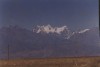
Why a group page
for the Bogda Shan? I have several reasons for this. First I
have set myself the goal of giving all the 113 peaks of the Bogda
over 4000 meter a mountain page one day. But everybody will
understand that that is not a job I will have finished next month or
even next year: By now I have enough material and knowledge for
about 15 of the intended pages - and even putting up those goes slow
as my time is limited -, so there is a gargantuan job to be done
before I can realize my intentions. So my first goal is to have at
least something at hand about the complete set at mountains.
Most of you will not know the Bogda Shan group, and those
who know its name probably have no knowledge of any detail. OK, I
admit that this page makes for an evening or more of tough reading
and geographical study, but if you combine that with purchasing the
Bogda Uia issue in the "Snow mountains of China" map series,
you will have gathered quite intrinsicate knowledge of the range.
So, another goal is to educate you about this magnificent range of
West China, which is the most accessible high mountain area of
entire China.
In the chapters about the individual
mountains I will all the time add an active link, once a page about
that specific mountain has come up. So this is meant to be a kind of
starting page for Bogda Shan in the future where one can pick a
mountain according to its height, specific difficulty, position in
the range or other and click through to the preferred object. For a
start now we will have to do with only four active links as this is
the number of mountains of the Bogda that already have a summitpost
page.
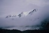
A more general motive is promoting my most beloved
range. Sure, I love the giants of the Central Tien Shan, the
Kunlun, the Karakoram, Pamir and so on, but when it comes to it:
There is nothing like the Bogda! When I wake up in the
morning I see the splendid glaciers and the jagged peaks on the
horizon, and even the 5000th time is a revelation in itself. With
large Urumqi city at only 54 Kilometer from the main
Bogda peak and road connections into the foothills and even up to
Tianchi lake being fair, the potential for development of
mountaineering in this range is greater than with everything else in
China.
Climbing in Urumqi is quickly becoming popular and
with several friends I am setting up plans now for building and
manning a European style mountaineering and hiking hut at the
head of the Sangecha gully from where access to well over a
dozen of the peaks in this page will be easy. We are sure that the
hut will speed up the gaining of popularity of the bogda mountains.
Further plans include the setting up of a rock and ice climbing
centre/school by Hu Fung Ling at Salt Lake settlement,
close to the Southern foot of the Bogda. So see this page as
pure promoting of Bogda: Its days in the sun of mountaineering will
soon come, and I want you all to know this cheap possibility of high
altitude mountaineering in West China.
Besides all other
reason, I just like to make, every now and then, a nice detour from
my own scientific specialisations - Hydrology, Ichytiology and
Ecology - into the field of geography. Now, I know that compared to
men like Mi Desheng I am only an amateur, but at least one
that knows what he is doing.
The clearly most
convenient place for starting a trip to Bogda Shan is Urumqi,
the 2.5 million capital of Xinjiang Uyghur autonomous region.
Nowadays Urumqi can be reached directly with several international
flights, including some coming from Europe, Moscow, Islamabad,
Almaty and Bishkek. It can also be reached conveniently by daily
internal flights from Beijing by China airlines, however it
might be most beautifull to take the 48 hour express train 4000
kilometer all through China, starting in Beijing. This is also a lot
cheaper than flying.
Urumqi has a very good, very modern
infrastructure and in its 20 outdoor shops you can find about
anything you will need for a trip in the mountains. Apart from this
it is the seat of the China Xinjiang Mountaineering
Association as well as the "No. 4 Sheep pen bar", (funny
way of saying "camp IV"), the hangout of the quickly growing local
climbing scene. Cheap and good hotel accomodation can be found
anywhere in the city, with double rooms with shower coming at
12-15 $ a night and dorm room beds at $ 3.
The usual approach of climbing in Bogda Shan is from the
North, and it takes a longer drive to get to the isolated South from
where you would start for climbing roughly half of the described
peak. From Urumqi a two hour drive brings you to one of the
entrances of the Northern gullies in the foothills of Bogda Shan at
around 1900 meter elevation. In summer a public bus goes all
the way to some of the villages at the entrances of the gullies, but
outside of season you will first have to go to Fukang an
persuade a taxi driver to bring you to the, now closed, desired
place. He might ask a little more for it than the fare his meter
indicates: The hairpin roads and bumpy tracks up the lower slopes
are not fun driving in winter! Another alternative is hiring a
jeep in Urumqi, which will cost about 350 yuan, (USD
40,-) to bring you to the desired starting point for a walk in.
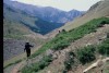
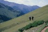
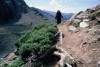
Most of the walk ins by way of the Northern gullies
will take two days to complete, but very strong hikers may make it
in just one day up some of the better gully trails. In winter it
goes up to at least 3 days as the snow will be deep in most parts
now. In all the villages at the gully entrances and at
Tianchi lake you can hire pack animals for transport
of your materials
The south of Bogda Shan, also
called Dabanshan is much less developed and that makes
getting there a little more difficult. As there are no public buses
to most of the higher settlements in the mountains you will have to
hire transport in Urumqi for the 150 kilometer there. As the
second half of the drive is in rough terrain, 4 wheel drive
jeeps are highly recommended. About every travel agency in town
can arrange one for you on short order. The total price for a jeep
drive to Sangecha and being picked up there again is 700
to 800 Rmb. or about 85-95 $.
The normal duration for
walk ins by way of the Southern gullies is also 2
days, although for the very long ones in the Southeast 3
days is probably more comfortable.
As there is very
little snowfall in the Dabanshan it remains quite accessible in
winter also and no more time is needed for the hikes than in summer.
Again here you can hire pack animals for material transport at the
villages at the end of the gullies.
Mountain
climbing on peaks of over 4000 meter requires a permit in China and
we are talking exclusively summits of 4002 up to 5448 meter here. In
principle for climbing any of these you need a official permit. They
will cost $ 30 per climber per peak. The China Xinjiang
Mountaineering Association is the organisation officially entitled
to issue this permits. The most direct way to obtain them is to
apply for it at their Urumqi office and you will pay upon the
issuing of the permit there. A second possibility is to contact a
local, licensed agent to do the paperwork with CXMA for you. In this
case it will get a little more expensive due to the commission the
agent charges. In season it is also possible to just go to the
entrance of the Tianchi Nature Preserve and pay the charge to the
warden of the Preserve. In all case, upon entering the preserve, you
will be due to pay a small charge for the Preserve also.
There is a distinctive difference between the North and the
South Bogda Shan. The Northern reaches, within the Tianchi Nature
Preserve resorting under the jurisdiction of CXMA as far as
mountaineering is concerned. The South, which is not part of any
Nature Preserve is another case. This area is under the jurisdiction
of the Sports Committee of the Dabanshan local Administration. At
present they do not charge any mountaineering fees, so here you are
free to go and climb whereever you want without charge. This might
however change in the future, so keep informed when planning to go
there!
It is likely that in the near future changes will be made
in the charges for peaks in China, as more and more area's go over
in control of private enterprises, but at the moment the following
peak fees for climbing mountains in
China are applicable. These fees are for peaks that have
been climbed at least one time before.
| MOUNTAIN |
PERMIT FEE |
MAX. GROUP SIZE |
| Qomolangma, (Mnt.
Everest) |
$ 5.000,- |
10 + Ex.Leader |
| Qogori,
(K2) |
$3.250,- |
10 + Ex.Leader |
| Cho
Oyu |
$3.000,- |
10 + Ex.Leader |
| Xixabangma, (Shisha
Pangma) |
$3.000,- |
10 + Ex.Leader |
| Other 8000+
Peaks |
$1.760,- |
10 + Ex.Leader |
| 7000 to 8000
Meter |
$1.080,- |
10 + Ex.Leader |
| 6000 to 7000
Meter |
$700,- |
10 + Ex.Leader |
| Below 6000
Meter |
$30,- |
Per Climber |
For
each member above the number of 10 an additional charge will be
made: 10% for every extra member.
Virgin
peaks, that is mountains who have never been climbed
before, have much higher peek fees. How much exactly is
charged depends on fact as whether it is in a closed or open area,
the exact height, how much interest is shown in it etc. In the
present the height of the fee has become somewhat negotiable,
depending on with who you are specifically dealing. This are the
ranges for fees, (note that in China peaks like unclimbed 8011
meter high Broad peak North summit are considered independent
objectives and thus are charged as being so);
| PEAKS OF: |
PERMIT FEE |
MAXIMUM GROUP SIZE |
| 8000 Meter and
Above |
$27.000,- to
$41.000,- |
10 + Ex.Leader |
| 7000 Meter and
above |
$1.500,- to
$10.000,- |
10 + Ex.Leader |
| 6000 Meter and
above |
$1.000,- to
$5000,- |
10 + Ex.Leader |
| Below 6000
Meter |
$30,- |
Per Climber |
Officially for
new routes on mountains that were already climbed by another
way the fees are twice as high as the normal price, but this
also has become negotiable, and they might just let you go on the
normal charge.
Being over 4000 meter, but lower than 6000
meter, the normal charge for a mountaineering permit on the
mountains described on this page would be $ 30,- per climber, but as
you can see in the red tape section it is avoidable, if one climbs
in the Southern, Dabanshan part because the peak is in the
Dabanshan, as there is no active permit policy enforcement
there.
Climbing in
Bogda Shan is still very much a summer affair. Chinese climbing is
still young and in the stage of "tackling the most obvious peaks on
their easiest routes and in the best season", so it was coincidence
that the first ever winter attempts were made simultaniosly during
the Chinese new year holiday this year. One party consisted of
myself and Bob Keaty, the other was a training course of local
guides under and instuctor of CXMA. However none of real
significance was climbed by either party.
So one could say
that summer is still the best season for climbing in the Bogda Shan,
say from late May to late September. But one should realize that the
precipation in the whole range is higher in summer and combined with
higher temperatures makes for greater avalanche danger. However, a
lot of the East and South slopes are mainly rock faces and only high
on the Northeast a small hanging glacier clings to it here and
unless you go directly under the glaciers snouts there is not much
avalanche danger except after unusually heavy summer snow fall.
Winter climbing in the Bogda Shan is feasible, we have
proven that recently. Amazing enough we found that conditions are in
fact no more difficult than in summer. With July and August being
the most snow rich months, winter does not see the special
difficulties with deep snow that are so characteristic for many
other mountain ranges. The South is completely lacking the problems
with deep snow on the approaches, that hamper climbing from the
north and snow layers in Sanchecha valley seldom exceeds 10 cm.
The other problem is the cold. The Tien Shan is a very
Northernly range and temperatures that are usual at 8 kilometer in
Himalaya and Karakoram are already found in Bogda at the moderate
altitudes of 4-5 kilometer. This means that for winterclimbing here
full expedition gear is necessary, with down suits being no luxury
at all. Good winter camping skills are also obligatory and
especially the cooking demands extra attention: Gas stoves are
troublesome in the extreme cold and kerosine burning is much more
reliable.
 |
Provided you
have paid for necessary permits, as far as the Tianchi preservation
area and the North Bogda Shan is concerned you are allowed to camp
out anywhere you like in the gullies, forests and on the mountains.
Take care however not to bother the local nomads and their
livestock. This is a pristine nature area, so be sure not to make a
mess out of your campsites. In the mountaineering camp sector of
this page you will find a whole set of convenient base camp spots
described.
complete set of
media in Urumqi gives weather forecasts for the entire region. But
it is somehow tricky to go for just the forecast for Urumqi city as
the mountains tend to create there own weather. Even a specific
forecast for the Bogda Shan can be misleading as the climate differs
greatly in the North and the South, and mostly the forecasts are
concerning the much wetter North.
Informing with your agent,
local or foreign, mostly should do the job. Myself I have contacted
one of the local Kazakh families and they have given me their
telephone number in order to get information from the spot
concerning the South of the range. I do not know however if they
will agree that I put it on SP, I will have to inform about that
next time I speak to them. The park warden of the Tianchi reserve
knows in detail what's up there and through the years has learned to
look at it with a mountaineers eye
On the web you will find
little to nothing about either weather or conditions, but in general
it can be said that both are generally good to excellent in the
South Bogda Shan, and somewhat more troublesome in the North,
especially in late summer. If you go to the Bogda Shan you are
always welcome to contact me as mostly I know what's up in the
mountains here.
 |
Note that this
are not data that apply for the higher slopes on the mountain but
general climatic data that apply for 1900 meter high Tianchi lake
and 1850 meter Sangecha settlement. The adiabatic cooling in the
Bogda is about 0.6 degree centigrade per 100 meter altitude gain:
This means that the summit region of 4275 meter Xifeng peak has an
average januari temperature of -32 centigrade, with daytime highs
not exceeding -18 and possible nightime temperatures going as low as
-45.
Chiefly under the influence of the northwest air
current and lying in the waist of the Asian Continent, the climate
of obvious characteristic produces such a fact that it is arid and
schorchingly hot on the level ground of the mountain foot and humid
and cold in the middle and upper section of the mountain area. The
four seasons are not so distinct, January being the coldest month
when the temperature averages - 16 C --- -19 C, while July, the
hottest month, has an average temperature of 10 --- 12 C. With the
yearly precipitation of no more than 200 mm, the months of July and
August have the heaviest rainfall, take 2/3 of that in one year. The
period for snow accumulation comes between the end of September and
that of May of the next year, during which time the snow is up to
about 65 centimeters and make it inconvenient to go onto the
mountains. The average velocity being 2.7 --- 2.9 meters per second,
strong wind seldom frequents the peak area. In one day, it generally
turns bad after noon when the velocity and cloudiness increase. In
short, it is advisable to have mountaineering activities in the
three months of June, July and August of a year.
*****Thanks to
China Xinjiang Mountaineering Association for providing the
data
Most of the
Central Asian high mountain ranges are reknowned for their foul and
changeable weather. Good examples are the Pamir and the Central Tien
Shan where so many climbers and hikers have been killed by sudden
breaks in the weather. Probably at Kongur Shan in the Western Kunlun
it is worst with, seldomly periods of good weather lasting more than
a day or two.
The Bogda Shan is however an exception to this
rule. Weather in the whole range is often good and stable for long
periods, and even climbing in the North is seldomly a problem in
summer season. There are however striking differences in the weather
patter between the Northern and the Southern slope. All the more
remarkable because the distances are tiny for mountain standards.
The North is usually quite wet in summer with regular
snowfall and relatively low temperatures, but warm in the days,
making climing a hazardous adventure on many routes. On the
Contrary, the South is exeedingly hot during summer days with no
precipation to speak of. Most of the (few) Southern glaciers are
bare ice in the summertime and there are few to no avalanches.
Nightime summer temperatures do not differ to much but those in the
South are slightly higher.
Winter sees an even bigger
disparity. The North receives considerable snowfall and from
beginning december all through April it is almost impossible to walk
into the base camps at the foot of the mountain, because of waist to
shoulder deep snows. In summer it already takes 2 days to walk in,
in winter it becomes rather 4-5. But surprise, the South is
extremely accessible in wintertime: Almost no snowfall at all and
even 15 cm is exceptionally deep. If there is any snow, it will
evaporate very quickly in the extreme dry air. All the major gullies
of the South Bogda or Dabanshan, of which Sangeecha is the major one
are indeed winter pasturing area's of the local herders!
The
setback with all this good news are the very low temperatures that
are the rule. Even with the fact that 95% or more of the winter days
are very bright and sunny the temperature above 2000 meter never
gets above -15 centigrade and in cold nights can fall well below
-40. This makes for that it is not a place for unexperienced winter
climbers/campers to go to. Camp here in winter demands utter
discipline and the best of materials. When we got there we used LPG
gas as fuel, but kerosine would be much better as the gas containers
get so cold that special measurements are necessary to get them
going.
Winter nights in the Dabanshan are exceptionally
long: By six in the evening it is pitch dark, - Well there are
always the 10's of thousands of stars and if you are lucky a bright
full moon -, and daylight is only full again at 10 in the morning.
Although thus you have very short days for climbing and hiking
activities, it is a real torture to start up your brewing and
cooking activities before the sun hits the tent. When finally the
hut will be there, things will become a lot easier, allowing
visitors to start real early, hit the road when the sun comes up,
and only returning when darkness falls again.
To add one
more good thing to the winter conditions of the whole Bogda Shan:
Strong winds are most unusual in the entire area. In the North
typical windspeeds are 2-4 meter per second and the South is even
beter, it is mostly completely windstill over there. All these
niceties have however one setback: With the absence of wind and zero
percent air humidity you are often not aware how cold it really is
and that could bring you viscious frostbite without even noticing
its development.
 |
The peaks and
glaciers that are described on this page are all found in the West
Bogda Shan, This is only about 40 % of the surface area of the
range. It stretches for many dozens of kilometers eastwards.
Although the highest part of the range is found within the described
area and the density of peaks is highest here, a whole score of
peaks over 4000 meter are found in the eastern part. This part of
the Bogda is however much less well know, much more difficult to
reach and much less populated, so as I lack real knowledge about it
I have left it out of the description for now. When my knowledge
will expand in the future, I may add this area to the page.
The area that is covered on this page has a West East axis
of 47 Kilometer and a North-South axis of 37 kilometer, so a total
surface area of 1739 square kilometer, or about 39% of the entire
Bogda Shan. It is found withing the following extremities:
NORTHWEST;
East; 88 Degrees 00 Minutes
North; 44
Degrees 00 Minutes
SOUTHWEST;
East; 88 Degrees 00
Minutes
North; 43 Degrees 40 Minutes
NORTHEAST;
East: 88 Degrees 35 Minutes
North; 44 Degrees 00 Minutes
SOUTHEAST;
East; 88 Degrees 35 Minutes
North; 43
Degrees 40 Minutes
Several good
maps of the Bogda Shan mountain range are in existance and they are
readily available at the better bookshops in Urumqi. A good choice
would be the locally available topographic maps on 1;100.000 scale:
They are not to expensive and fairly accurate, but on a to large
scale to enable you to do any climbing planning in detail.
Disadvantage however is that they are in Chinese.
By far the
best choice however would be to purchase the 1;50.000 "Bogda Uia"
issue in the "snow mountains of China" series, produced by the
Lanzhou Institute of Glaciology and Geocreology. It is a pretty
price map, but it is about the best in its sort. Top knotch map
dealers aroung the world should be able to order this map for you
under ISBN no. 7-80545-148-6/K.148 at the Xian Cartographic
Publishing House, 124 Youyi East Road, Xian, China 710054.
If this fails, you could also ask directly at the Lanzhou
Institute of Glaciology and Geocryology: 260 Donggang West Road,
Lanzhou, China 730000, tel. no.00869318278299, fax. no.
00869318885241, e-mail, liggplan@ns.lzb.ac.cn.
If everything
else fail you could contact the authorized dealer for the "snow
moutains of China" maps in Xinjiang: Mr Kong Baocun,
kongtour@urumqi.cngb.com At a price of about $30,- per map (+
sending costs), he is able to sent you any of the 13 maps of this
serie. Be sure to mention in your request that you want the map in
the English language.
Nowadays you can also order the Snow
Mountains of China maps online: Order the Bogda Shan Map.
You should however be aware that none of the maps available
for Bogda is a detailed topo as are available for most mountains in
Europe and North America. Route finding thus is still a matter of
personal skill and intuition and should not be taken lightly: The
map is only a general help.
Like in many countries the top
knotch in maps consists of the most recent prints of military staff
maps, but unlike in some European countries they are not openly
available for the general public. It is completely forbidden for
foreigners to be in possession of this kind of maps which exist in
1;25.000 and 1;50.000 varieties. Also the vast majority of Chinese
citizens is excluded from buying copies.
However, public use
of staff maps is not totally blocked: Certain personal members of
companies licensed to work in mountain climbing & hiking, with a
special paper signed and stamped by the leadership of the company
are allowed to buy certain maps from the military series.
As
my company is officially working here in the mentioned activities
and we do have a Chinese personnel member, since short we have
permission to buy maps concerning the mountain area's we are active
in, including the Bogda Shan. The maps are of extraordinary quality,
but nothing of it may be copied or leave the People's Republic of
China. If however you come to Urumqi and you can reasonably convince
us that you intentions are strickly recreational, you can contact us
and could use our maps or we buy copies for you, - On the written
promise you will not try to take them home -
In order to keep
a little sane during working on the material for this page, I here
and there used abbreviations. Although I tried to keep that as
little as possible, here a list of what it means.
d.=Degrees
m.= Minutes
Deg.= Degrees
Min.= Minutes
Sec.=
Seconds
Lat.= Latitude
Long.=Longitude
Mnt.=Mountain
Gl.=Glacier
N.=North
E.=East
S.=South
W.=West
NE.=Northeast
SE.=Southeast
SW.=Southwest
NNE.=Northnortheast
ENE.=Eastnortheast
ESE.=Eastsoutheast
SSE.=Southsoutheast
SSW.=Southsouthwest
WSW.=Westsouthwest
WNW.=Westnorthwest
NNW.=Northnorthwest
CMA=China
Mountaineering Association
CXMA=China Xinjiang Mountaineering
Association
m.=Meter
met.=Meter
km.=Kilometer
Km.=Kilometer
Ur.= Urumqi
AofS=China Academy of
Sciences
 |
In the chapters
of the 117 mountains you will find the stating of a map kwadrant
code, indicating where the peak can be found on the "Snow Mountains
of China" map, (Which is gridless) This works as follows: Fold the
map double on its length axis and after that fold it double twice in
its North South axis. The following numbered division into 8 parts
emerges then:
1......2......3......4
5......6.......7.....8
As you see the digit is in
all cases followed by a letter, somthing like 5b. the letter is
assigned in the following way. Take one of the 8 map parts and
divide it like;
a.....b
d.....c
Thus the map
is divided in 32 seperate parts, which makes it much easier to find
an individual peak on it. Hope this makes sense to you.
Making a list of
mountains is always somewhat arbitrary, as, whatever you do, you
never please everybody with the system you choose. What is a
mountain? According to the UIAA a peak can be called an independent
mountain if it has a drop to a col or saddle to the nearest higher
one of at least 400 meter. Other methods of determining independency
of peaks involve rules like a drop of 8% at least to the nearest
higher ones. I am of the opinion that both rules are completely
unworkable in young ranges like the ones of West China. I will give
you an example: In the Central Kunlun we find the Kaxtax Shan with
its unbroken Southwall facing the great Kunlun rift for over 125
kilometer. There are found over 80 peaks in the ridge spreaded over
its entire length, but if we apply the rules mentioned here before,
there would only be 1 peak that could be classified as
"independent", The highest, Kaxtax I! 6700 meter peaks that are over
85 kilometer distant should, if the rules were applied to the
letter, be called: Kaxtax Northwest nr 71 summit and so on. Hope you
can see how ridiculous this is!
Now in China we have a very
nice and practical rule avoiding all this nonsense. CMA stated long
a go "A mountain is a mountain if climbers think its a worthwhile
goal in itself for an ascent" Maps here are made with this in the
mind and that results in a pretty practical solution. I compared the
"Snow Mountains of China" map of the Bogda Shan with the most recent
issue of the corresponding Military staff maps, and if doubt did
arise I gave preference to the staff maps information. Thus I ended
up with 113 peaks of over 4000 meter. In the namegiving however I
have built in the 400 meter rule. If a drop in comparison to the
main peak is less than this I expressed that in the name: For
instance the drop from Main Xifeng Peak to the SW peak is less than
400 meter, so I called it "Xifeng Southwest Peak" The drop to the
South peak however is much greater than 400 meter so I called it
"South Xifeng"
Hope it is all a bit comprehensible to you
all, but it remains that one always can discuss classification
systems
Different maps
often give different heights for the same peak. As it is pretty
nasty bussiness to go measure everything yourself one has to make a
choice when compiling mountain lists. I have choosen for this
listing to use the values of the Military staff maps of the 1996
edition. This results however that if you compare my values with
those on the snow mountains of China map of Bogda Shan, you will
find slight differences, (although in no case more than 30 meters).
A lot of the mountains are a few meter lower in the values that I
have used, only boda V, (1 meter) and Bogda I, (3 meter) are higher
on the military maps. It has painstakingly been proven that Bogda I
is indeed 5448 meter and not 5445 meter as was long believed.
However the old value has stuck in many uses. For example we have a
outdoor shop here called "5445" and it had little craving for
several reasons to change its name: 5448 does not sound so
nice!
A mountain must
have coordinates in order for someone to be able to find it on a map
or by way of GPS compass tracing. Now, it sucks that the best map
available for the general public does not have a grid, (Bogda Uia
entry in the "Snow mountains of China" map series). For certain the
military staff maps have a very precise grid and on this the entries
of Longitude/Latitude is based. However, among the entire membership
of Summitpost there are at best 8 people who have legal access to
Chinese military maps, and Kenzo Okawa and Me are the only non
Chinese among them. This sucks too, but that is the way it is. With
the data I am giving in the 113 Mountain chapters and the 83 glacier
chapters it is however easy for you to draw a grid on the Bogda Uia
map, at least if you are in possesion of basic knowledge of grids,
but I guess that is available with most SP members.
The
Longitude/Latitude entries are found in the following form here:
Example: "East 88 Deg. 16 Min. 7"
88 here is the
gradiant meaning that the peak is on the Eastern part of the globe,
88 degrees to the East of Greenwich where the Eastern 0 degree is
found, this al on a scale running from 0 to 180 - The entire globe
know 360 degrees, like all spherical objects, and is evenly divided
in a western and a eastern hemisphere -
16 means that the
position of the peak is 16 minutes in excess of 88 degrees exactly
on a scale running from 0 to 60 minutes.
7 is a DECIMAL number
here, not seconds like are used in the classical geography. 7 means
that the peak is 70% of a minute in excess of 88 degrees and 16
minutes. So in the classical notation it would be "88 degrees 16
minutes 42 seconds". As however modern GPS equipment uses decimal
notation instead of seconds, I decided to do the same, so you can
directly enter the numbers to your satelite compass. (Well, next
year the new Galileo system comes into use and its said that they
will go back to classical display again.

In all the 113 mountain chapters you will found a "Probably
easiest route" mentioned. This is done, solely with idea of getting
to the summit of the peak so that the least technical difficulties
are encountered. Objective danger have been NO consideration in it
and once at a certain peak you may not find it advisable to take the
route here indicated as "easiest" in view of avalanche exposure or
other dangers.
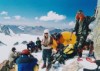
About 25 routes in the Bogda have been
established, and detailed knowledge of them exists. Whether this is
the case with a route you contemplate, look in the same chapter of
the mountain to the "Climbed status" part. If this says "climbed" or
"climbed several times" than you can be sure the information is
detailed and not purely theoretical.
However this leave over
85 of the routes being yet unclimbed. A few of them have been tried
but unsuccesfully, others we still lack all practical information
about it. How then the conclusion about the route comes into being?
Through thorough map study and from my own personal observations and
those of a few others. So, the information is theoretical. However,
I am now 34 years in mountain climbing and have been guiding on 32
expeditions, many of them to unknown, unvisited peaks, so you may
assume that I know pretty exactly what I am doing. But: NEVER, EVER
TAKE FOR GRANTED INFORMATION ABOUT UNCLIMBED ROUTES: ALWAYS CHECK
THE NATURE OF YOUR INFO EVEN IF IT COMES FROM REINHOLD
MESSNER!!!!!!!!!!!!!!!!!!!!!!
As you can see from the
various entries, the Bogda Shan is not really an area fit for hikers
and peakbaggers. Only two of the routes have gotten the
classification "Hike" and one other "Hike/Easy". Most of them are
medium and highly technical climbs, the vast majority being of mixed
character. A few of them are really desperate ones. Remember that I
mention the "easiest" route in each case, and that often on the same
mountain much, much harder routes are to be found. You want to know
what is the hardest mountain in the Range? In my view that is Bogda
V, very hard on all routes, but others come close to it. So, if you
are a hiking mountaineer, should you stay at home? By no means! I am
talking the 4000+ mountains, among the lower ones there are
literally dozens that make for excellent hiking summits. Not
concerning oneself with summits but just hiking the gullies and
passes makes for an experience, which the vast majority of you will
find very hard to find near your home!
For all the
"Probable easiest route's" on the 113 mountains an indication is
given of its technical difficulty. Of some of the more well known
routes it would have been possible to give a more detailed
description, complete with various grades in the UIAA, Alpine or
Russian sense. But the vast majority of the routes is not known in
detail, so I have left it with a more general description for all of
them within the following categories:
-
Hike........................No Technical difficulties
-
Hike/Easy..............A little bit of scrambling involved
-
Easy.......................Scrambling
- Rather
Easy..........Hard scrambling
- Fairly Easy.............A
few lower grade technical difficulties
- Moderately
Hard...Lower/medium grade technical difficulties
- Fairly
Hard.............Continuous Lower/Medium grade difficulties
- Rather Hard...........Some Middle/Higher grade
difficulties
- Hard........................Continuous
Middle/Higher grade difficulties
- Very
Hard...............Continuous Higher grade difficulties
On all 113
mountain chapters I have given some information about the climbed
status of the peak in question. For some this information is dead
sure, but it is very hard to get good information about the
majority, especially as in the South part of the range a permit is
not necessary and no registration of climbs comes into being. So,
unfortunately I ended up with a lot of "unknown" entries. If I state
that the peak is still unclimbed, that does not give a 100%
garantuee that this is so: It is all to easy to miss something. What
is sure is that a great number of the bogda peaks is still
unclimbed, so here is a marvellous "playgarden" for the exploratory
mountaineer.
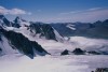
The Bogda Shan
range is distinctively divided in 47 clearly recognizable mountain
groups, separated from each other by the deep riverine gullies that
are so characteristicly for the area. 18 of these groups contain
peaks of over 4000 meter. In the chapter of each peak it is
mentioned to what group it belongs. The distinction is thus that it
leaves little space for discussion. Only Sigong peak is a odd one
out and I have not assigned it to any group. Sometimes however it is
seen as belonging to the main Bogda group, (geologically doubtfull).
Others give it a group for its own, (Doubtfull as the group contains
only a single peak)
With all the
mountain chapters, the best access way is indicated. What exactly
does it mean? The way indicated will lead you to the start of the
"easiest route" mentioned in the same chapter. In order to climb
alternative routes on the same peak you might have to start up a
completely different gully, or even approach from the North Bogda
instead of the South.
Most access routes to climbs on the
high peaks of Bogda will take two days and using pack animals for
material transport is highly recommended for all trips except short,
lightweighted, alpine style dashes. At the entrance to almost all
the gully's there are settlements of semi nomadic herdsmen and it is
never difficult to rent pack animals.
Acces to most of
the main groups containing 4000+ Peaks in the Bogda Shan is fairly
easy because of the pressence of a system of dozens of riverine
gullies, carving the range up into its main mountain groups. 23 of
this gullies are listed below, with information about their
entrance, head, position, direction and to which mountain group(s)
they give access. As you can see almost all the gullies run in
either North South of South North direction. Some have fairly good
trails in them, but the terrain in most is hard hiking terrain and
although the distances are not so large in the absolute sense, most
of the walk ins will take 1.5 to 2 days to complete, (longer in the
Northern gullies in winter, as there will be very deep snow).
| Topic |
Answer |
| Listnumber of Gully |
1 |
| Name of Gully |
Qongkanr Gully |
| Entrance of Gully |
Shunmogiou Settlement |
| Longitude of Entrance |
East:88 Degrees 07 Minutes 00 |
| Latitude of Entrance |
North:43 Degrees 46 Minutes 00 |
| Length of the Gully |
15 Kilometer |
| Gives access to |
Northside of Malu Group |
| General Direction of Gully |
North to South |
| Topic |
Answer |
| Listnumber of Gully |
2 |
| Name of Gully |
Malu Gully |
| Entrance of Gully |
Middle Ziyenzan Gully |
| Longitude of Entrance |
East:88 Degrees 09 Minutes 00 |
| Latitude of Entrance |
North:43 Degrees 46 Minutes 5 |
| Length of the Gully |
8 Kilometer |
| Gives access to |
Northside of Malu Group |
| General Direction of Gully |
North to South |
| Topic |
Answer |
| Listnumber of Gully |
3 |
| Name of Gully |
Ziyenzan Gully |
| Entrance of Gully |
South Shore of Tianchi Lake |
| Longitude of Entrance |
East:88 Degrees 12 Minutes 00 |
| Latitude of Entrance |
North:43 Degrees 47 Minutes 00 |
| Length of the Gully |
13 Kilometer |
| Gives access to |
Northside of Ico Group |
| General Direction of Gully |
Northwest to Southeast |
| Topic |
Answer |
| Listnumber of Gully |
4 |
| Name of Gully |
Karamsak Gully |
| Entrance of Gully |
Middle Ziyenzan Gully |
| Longitude of Entrance |
East:88 Degrees 14 Minutes 00 |
| Latitude of Entrance |
North:43 Degrees 48 Minutes 50 |
| Length of the Gully |
7 Kilometer |
| Gives access to |
Eking Peak |
| General Direction of Gully |
Northwest to Southeast |
| Topic |
Answer |
| Listnumber of Gully |
5 |
| Name of Gully |
Akibulak Gully |
| Entrance of Gully |
Lower Daong Gully |
| Longitude of Entrance |
East:88 Degrees 13 Minutes 00 |
| Latitude of Entrance |
North:43 Degrees 50 Minutes 50 |
| Length of the Gully |
4 Kilometer |
| Gives access to |
Northside of Akibulak peaks |
| General Direction of Gully |
North to South |
| Topic |
Answer |
| Listnumber of Gully |
6 |
| Name of Gully |
Daong Gully |
| Entrance of Gully |
Lower Ziyenzan Gully |
| Longitude of Entrance |
East:88 Degrees 15 Minutes 00 |
| Latitude of Entrance |
North:43 Degrees 51 Minutes 00 |
| Length of the Gully |
8 Kilometer |
| Gives access to |
Sangecha Glacier |
| And |
Northside of Xifeng Group |
| And |
Sigong Glacier |
| General Direction of Gully |
NorthWest to SouthEast |
| Topic |
Answer |
| Listnumber of Gully |
7 |
| Name of Gully |
Sigong Gully |
| Entrance of Gully |
South Shore of Tianchi Lake |
| Longitude of Entrance |
East:88 Degrees 18 Minutes 00 |
| Latitude of Entrance |
North:43 Degrees 50 Minutes 00 |
| Length of the Gully |
20 Kilometer |
| Gives access to |
Northside of Main Bogda Group |
| And |
Northside of East Bogda Group |
| And |
Jianshi Group |
| General Direction of Gully |
North to South |
| Topic |
Answer |
| Listnumber of Gully |
8 |
| Name of Gully |
Qoratalak Gully |
| Entrance of Gully |
Aksay village |
| Longitude of Entrance |
East:88 Degrees 19 Minutes 00 |
| Latitude of Entrance |
North:43 Degrees 52 Minutes 00 |
| Length of the Gully |
8 Kilometer |
| Gives access to |
West side of Ganghe Group |
| General Direction of Gully |
North to South |
| Topic |
Answer |
| Listnumber of Gully |
9 |
| Name of Gully |
Ganghezi Gully |
| Entrance of Gully |
Middle Qoratalak Gully |
| Longitude of Entrance |
East:88 Degrees 21 Minutes 50 |
| Latitude of Entrance |
North:43 Degrees 52 Minutes 00 |
| Length of the Gully |
7 Kilometer |
| Gives access to |
N. & S. side of Ganghe Group |
| General Direction of Gully |
North to South |
| Topic |
Answer |
| Listnumber of Gully |
10 |
| Name of Gully |
Koko Gully |
| Entrance of Gully |
Lower Xigou Gully |
| Longitude of Entrance |
East:88 Degrees 23 Minutes 50 |
| Latitude of Entrance |
North:43 Degrees 42 Minutes 00 |
| Length of the Gully |
7,5 Kilometer |
| Gives access to |
Northside of Koko Group |
| General Direction of Gully |
Northeast to Southwest |
| Topic |
Answer |
| Listnumber of Gully |
11 |
| Name of Gully |
Xigou Gully |
| Entrance of Gully |
Baiyang Mining Area |
| Longitude of Entrance |
East:88 Degrees 25 Minutes 00 |
| Latitude of Entrance |
North:43 Degrees 50 Minutes 00 |
| Length of the Gully |
19 Kilometer |
| Gives access to |
Eastside of Koko Group |
| And to |
Baiyang Glacier |
| And to |
Northside of East Bogda Group |
| General Direction of Gully |
North to South |
| Topic |
Answer |
| Listnumber of Gully |
12 |
| Name of Gully |
Xishan Gully |
| Entrance of Gully |
Naifengshian Village |
| Longitude of Entrance |
East:88 Degrees 32 Minutes 00 |
| Latitude of Entrance |
North:43 Degrees 52 Minutes 50 |
| Length of the Gully |
14 Kilometer |
| Gives access to |
Northside of Xishan Group |
| General Direction of Gully |
North to South |
| TOPIC |
ANSWER |
| Listnumber of Gully |
13 |
| Name of Gully |
East Xigou Gully |
| Entrance of Gully |
Baiyang River Valley |
| Longitude of Gully Entrance |
88 Degrees 29 Minutes 0 |
| Latitude of Gully Entrance |
43 Degrees 50 Minutes 5 |
| Length of Gully |
9 Kilometer |
| Gives Access to |
Northside of North Aksu Group |
| And |
Westside of Xishan Group |
| General Direction of Gully |
South to North |
| Topic |
Answer |
| Listnumber of Gully |
14 |
| Name of Gully |
Huangshan Gully |
| Entrance of Gully |
Huangshantaizi Settlement |
| Longitude of Entrance |
East:88 Degrees 33 Minutes 00 |
| Latitude of Entrance |
North:43 Degrees 42 Minutes 50 |
| Length of the Gully |
12 Kilometer |
| Gives access to |
Eastside of Xishan Group |
| General Direction of Gully |
Northeast to Southwest |
| Topic |
Answer |
| Listnumber of Gully |
15 |
| Name of Gully |
Akobay Gully |
| Entrance of Gully |
Lower Baiyang Gully |
| Longitude of Entrance |
East:88 Degrees 05 Minutes 00 |
| Latitude of Entrance |
North:43 Degrees 44 Minutes 00 |
| Length of the Gully |
4,5 Kilometer |
| Gives access to |
Northwest side of Malu Group |
| General Direction of Gully |
South to North |
| Topic |
Answer |
| Listnumber of Gully |
16 |
| Name of Gully |
Karaqorak Gully |
| Entrance of Gully |
Middle Baiyang Gully |
| Longitude of Entrance |
East:88 Degrees 07 Minutes 50 |
| Latitude of Entrance |
North:43 Degrees 45 Minutes 00 |
| Length of the Gully |
4,5 Kilometer |
| Gives access to |
Eastside of Malu Group |
| And to |
Westside of Ico Group |
| General Direction of Gully |
South to North |
| Topic |
Answer |
| Listnumber of Gully |
17 |
| Name of Gully |
Baiyang Gully |
| Entrance of Gully |
Shihuichang Village |
| Longitude of Entrance |
East:88 Degrees 13 Minutes 00 |
| Latitude of Entrance |
North:43 Degrees 45 Minutes 00 |
| Length of the Gully |
15 Kilometer |
| Gives access to |
Southside of Ico Group |
| And to |
Westside of Sangecha Group |
| General Direction of Gully |
Southwest to Northeast |
| Topic |
Answer |
| Listnumber of Gully |
18 |
| Name of Gully |
Sangecha Gully |
| Entrance of Gully |
Sangecha Village |
| Longitude of Entrance |
East:88 Degrees 16 Minutes 5 |
| Latitude of Entrance |
North:43 Degrees 46 Minutes 5 |
| Length of the Gully |
18 Kilometer |
| Gives access to |
Eastside of Sangecha Group |
| And |
Southside of Xifeng Group |
| And |
Bogda V West and South Faces |
| And |
Eastside of Xifeng Group |
| And |
Northside of Nanfeng Group |
| And |
West Side of Nanfeng Group |
| General Direction of Gully |
South to North |
| Topic |
Answer |
| Listnumber of Gully |
19 |
| Name of Gully |
Bogda Gully |
| Entrance of Gully |
Haigouxiaodiu Village |
| Longitude of Entrance |
East:88 Degrees 21 Minutes 50 |
| Latitude of Entrance |
North:43 Degrees 47 Minutes 00 |
| Length of the Gully |
17 Kilometer |
| Gives access to |
Eastside of Nanfeng Group |
| And to |
Southside of Nanfeng Group |
| And to |
Southside of Main Bogda Group |
| And to |
Southside of East Group |
| And to |
Westside of Haigou Group |
| General Direction of Gully |
South to North |
| TOPIC |
ANSWER |
| Listnumber of Gully |
20 |
| Name of Gully |
Haigou Gully |
| Entrance of Gully |
Haigouxiaodiu Village |
| Longitude of Gully Entrance |
88 Degrees 21 Minutes 3 |
| Latitude of Gully Entrance |
43 Degrees 40 Minutes 0 |
| Length of Gully |
18,5 Kilometer |
| Gives Access to |
Eastside of Haigou Group |
| And |
South Face of Bogda II |
| And |
West Face of Aksu |
| And |
Westside of Hongfeng Group |
| Topic |
Answer |
| Listnumber of Gully |
21 |
| Name of Gully |
Hongou Gully |
| Entrance of Gully |
Middle Haigou gully |
| Longitude of Entrance |
East:88 Degrees 26 Minutes 50 |
| Latitude of Entrance |
North:43 Degrees 44 Minutes 00 |
| Length of the Gully |
6 Kilometer |
| Gives access to |
Southside of Hongfeng Group |
| General Direction of Gully |
Southwest to Northeast |
| Topic |
Answer |
| Listnumber of Gully |
22 |
| Name of Gully |
Aksu Gully |
| Entrance of Gully |
Aksu Village |
| Longitude of Entrance |
East:88 Degrees 30 Minutes 00 |
| Latitude of Entrance |
North:43 Degrees 50 Minutes 00 |
| Length of the Gully |
34 Kilometer |
| Gives access to |
Southside of Aksu Group |
| And |
Northside of Aksu Group |
| And |
Eastside of Aksu Group |
| And |
Eastside of Hongfeng Group |
| And |
West Side of Zhongcha Group |
| And |
West Side of Ergong Group |
| And |
South Side of Xishan Group |
| And |
East Side of Xishan Group |
| General Direction of Gully |
South to North |
| Topic |
Answer |
| Listnumber of Gully |
23 |
| Name of Gully |
Daxigou Middle Gully |
| Entrance of Gully |
Aksu Village |
| Longitude of Entrance |
East:88 Degrees 33 Minutes 00 |
| Latitude of Entrance |
North:43 Degrees 48 Minutes 00 |
| Length of the Gully |
38 Kilometer |
| Gives access to |
Northside of Ergong Group |
| And to |
Westside of Ergong Group |
| And to |
Eastside of Zhongcha Group |
| And to |
Southside of Zhongcha Group |
| General Direction of Gully |
Southwest to
Northeast |
( More "23 Major access gullies of Bogda Shan"
photos/images | All Bogda Shan Mountain Group photos/images )
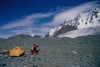
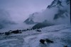
The whole of the
Bogda Shan is a dreamed of area for camping and as the whole range,
including the Tianchi preservation region, is meant for tourist
development, it is allowed anywhere. For mountaineering however, you
want places conveniently close to the start of climbs. Several of
the camps listed below are regularily used by climbers already, some
I have selected just because the are conveniently situated for
certain mountains and have yet to be discovered in reality. At one
place a primitive shack has already been built, the traditional
Bogda base camp. We are now in a far stage of planning for a real,
European style Mountaineering hut at the head of the Sangecha valley
from where a whole score of peaks can be climbed. With all the camps
a few mountains are mentioned that are convenient to climb starting
at this spot. This in no way means that not also other peaks can be
reached from a certain camp: I just made a selection of the
mountains closest to camp.
| Topic |
Answer |
| List Number of Camp |
1 |
| Name of Camp |
North Erdaren Camp |
| Location of Camp |
Head of Qongkanr Gully |
| Longitude of Camp |
East:88 Degrees 07 Minutes 3 |
| Latitude of Camp |
North:43 Degrees 45 Minutes 7 |
| Altitude of Camp |
3400 Meter |
| Convenient Access Way |
Qongkanr Gully |
| Accessible Climbing Goals from here |
Akobay Peak |
| And |
Erdaren Peak |
| And |
Karaqorak Peak |
| And |
Karaqorak Southwest Peak |
2)
KARAQORAK CAMP
Location;.....................Side branch of
Middle Baiyang gully
Longitude;..................88 Degrees
07 Minutes 7
Latitude;......................43 Degrees 43
Minutes 9
Altitude;.......................3280 Meter
Getting there;.............Baiyang gully
Peaks to
climb;.........Erdaren
.....................................Karaqorak
.....................................Karaqorak Southwest Peak
.....................................Karaqorak Souteast Peak
| Topic |
Answer |
| List Number of Camp |
3 |
| Name of Camp |
Malu Gully Head Camp |
| Location of Camp |
Head of Malu Gully |
| Longitude of Camp |
East:88 Degrees 09 Minutes 1 |
| Latitude of Camp |
North:43 Degrees 46 Minutes 4 |
| Altitude of Camp |
3420 Meter |
| Convenient Access Way |
Ziyenzan/Malu Gully |
| Accessible Climbing Goals from here |
Malu Peak |
| And |
Malu North Peak Peak |
| Topic |
Answer |
| List Number of Camp |
4 |
| Name of Camp |
Ziyenzan Gully Head Camp |
| Location of Camp |
Snout of Ziyenzan Glacier |
| Longitude of Camp |
East:88 Degrees 12 Minutes 0 |
| Latitude of Camp |
North:43 Degrees 46 Minutes 8 |
| Altitude of Camp |
3425 Meter |
| Convenient Access Way |
Ziyenzan Gully |
| Accessible Climbing Goals from here |
Ico Peak |
| And |
Ico West Peak |
| And |
Ico Northwest Peak |
| And |
Ziyenzan Peak |
| And |
Ziyenzan West Peak |
| And |
Ziyenzan Northwest Peak |
5)
BAIYANG LAKE CAMP
Location;.....................South
Tianchi lake shore
Longitude;..................88 Degrees 13
Minutes 4
Latitude;......................43 Degrees 44
Minutes 9
Altitude;.......................3540 Meter
Getting there;.............Baiyang gully
Peaks to
climb;.........Ico
.....................................Tianchi
West Peak
.....................................Tianchi South
Peak
.....................................Ziyenzan
.....................................Ziyenzan East Peak
| Topic |
Answer |
| List Number of Camp |
6 |
| Name of Camp |
Tianchi North Glacier Snout Camp |
| Location of Camp |
Bank of West Xifeng Stream |
| Longitude of Camp |
East:88 Degrees 13 Minutes 7 |
| Latitude of Camp |
North:43 Degrees 47 Minutes 3 |
| Altitude of Camp |
3400 Meter |
| Convenient Access Way |
Ziyenzan Gully |
| Accessible Climbing Goals from here |
Eking Peak |
| And |
Tianchi Peak |
| And |
Tianchi North Peak |
| And |
Tianchi Northwest Peak |
| And |
Tianchi Peak |
| And |
Xifeng Southwest Peak |
| And |
Xifeng Northwest Peak |
7)
SANGECHA GLACIER CAMP
Location;.....................Snout of
Sangecha glacier
Longitude;..................88 Degrees 16
Minutes 7
Latitude;......................43 Degrees 48
Minutes 9
Altitude;.......................3640 Meter
Getting there;.............Sangecha gully
Peaks to
climb;.........Sigong
.....................................Bogda
V North Peak
.....................................Bogda V North
II Peak
.....................................Bogda V
.....................................Bogda IV
.....................................Bogda I North Peak
.....................................Bogda I Northwest Peak
.....................................Bogda I
| Topic |
Answer |
| List Number of Camp |
8 |
| Name of Camp |
Bogda Main Base Camp Camp |
| Location of Camp |
Northern End Moraine of Sigong Glacier |
| Longitude of Camp |
East:88 Degrees 19 Minutes 0 |
| Latitude of Camp |
North:43 Degrees 49 Minutes 3 |
| Altitude of Camp |
3900 Meter |
| Convenient Access Way |
Sigong Glacier |
| Accessible Climbing Goals from here |
Jianshi Peak |
| And |
Jianshi West Peak |
| And |
Bogda VI Peak |
| And |
Bogda I Peak Peak |
| And |
Bogda I North Peak |
| And |
Bogda I NorthWest Peak |
| And |
Bogda V Peak Peak |
9)
BAIYANG GLACIER CAMP
Location;.....................North
moraine of Baiyang Middle glacier
Longitude;..................88 Degrees 23 Minutes 2
Latitude;......................43 Degrees 49 Minutes 7
Altitude;.......................3575 Meter
Getting
there;.............Ganghezi gully/Baiyang glacier
Peaks to
climb;.........Baiyang
.....................................Baiyang East Peak
.....................................Bogda VII
.....................................Bogda VII Northeast Peak
.....................................Bogda III
.....................................Bogda III North Peak
.....................................Bogda II
.....................................Donggou
.....................................Donggou Northwest Peak
.....................................Donggou North Peak
.....................................Donggou North II Peak
| Topic |
Answer |
| List Number of Camp |
10 |
| Name of Camp |
Aksu Glacier Snout Camp |
| Location of Camp |
Termination of Aksu Glacier |
| Longitude of Camp |
East:88 Degrees 29 Minutes 3 |
| Latitude of Camp |
North:43 Degrees 47 Minutes 8 |
| Altitude of Camp |
3334 Meter |
| Convenient Access Way |
Aksu Gully |
| Accessible Climbing Goals from here |
North Aksu Peak |
| And |
North Aksu Southeast Peak |
| And |
Bogda II Northeast Peak |
| And |
Aksu Northeast Peak |
| Topic |
Answer |
| List Number of Camp |
11 |
| Name of Camp |
Middle Aksu Gully Camp |
| Location of Camp |
Upper Aksu Gully |
| Longitude of Camp |
East:88 Degrees 29 Minutes 3 |
| Latitude of Camp |
North:43 Degrees 45 Minutes 6 |
| Altitude of Camp |
3030 Meter |
| Convenient Access Way |
Aksu Gully |
| Accessible Climbing Goals from here |
Aksu East Peak |
| And |
Aksu South Peak |
| And |
Aksu East II Peak |
| And |
Hongfeng Northeast Peak
Peak |
| Topic |
Answer |
| List Number of Camp |
12 |
| Name of Camp |
Upper Haigou Gully Camp |
| Location of Camp |
Haigou Lake |
| Longitude of Camp |
East:88 Degrees 25 Minutes 3 |
| Latitude of Camp |
North:43 Degrees 44 Minutes 9 |
| Altitude of Camp |
3570 Meter |
| Convenient Access Way |
Haigou Gully |
| Accessible Climbing Goals from here |
Bogda II Southeast Peak |
| And |
Aksu Peak |
| And |
Daxigouxizi Peak |
| And |
Daxigouxizi Southeast Peak Peak |
| And |
Hongfeng North Peak |
13)
HAIGOUFENG CAMP
Location;.....................Bogda III
glacier
Longitude;..................88 Degrees 22 Minutes 9
Latitude;......................43 Degrees 45 Minutes 5
Altitude;.......................3720 Meter
Getting
there;.............Bogda gully
Peaks to
climb;.........BogdaVII South II Peak
.....................................Bogda VII South III Peak
.....................................Bogda VII South Peak
.....................................Bogda III
.....................................Bogda III South Peak
.....................................Haigou North Peak
14) BOGDA GULLY CAMP
Location;.....................Upper Bogda gully
Longitude;..................88 Degrees 21 Minutes 6
Latitude;......................43 Degrees 43 Minutes 6
Altitude;.......................3300 Meter
Getting
there;.............Bogda gully
Peaks to
climb;.........Nanfeng South Peak
.....................................Nanfeng Northeast Peak
.....................................Nanfeng East Peak
.....................................Bogda II South Peak
.....................................Haigou
.....................................Haigou South Peak
.....................................Haigou Southwest Peak
15) LOWER SANGECHA CAMP
Location;.....................Middle Sangecha gully
Longitude;..................88 Degrees 16 Minutes 5
Latitude;......................43 Degrees 43 Minutes 6
Altitude;.......................3050 Meter
Getting
there;.............Sangecha gully
Peaks to
climb;.........Sangecha
.....................................Sangecha North Peak
.....................................Sangecha West Peak
.....................................Sangecha Southwest Peak
.....................................Nanfeng Southwest II Peak
.....................................Nanfeng Southwest III Peak
| Topic |
Answer |
| List Number of Camp |
10 |
| Name of Camp |
Middle Sangecha Camp |
| Location of Camp |
Upper Sangecha Gully |
| Longitude of Camp |
East:88 Degrees 17 Minutes 0 |
| Latitude of Camp |
North:43 Degrees 45 Minutes 0 |
| Altitude of Camp |
3200 Meter |
| Convenient Access Way |
Sangecha Gully |
| Accessible Climbing Goals from here |
Nanfeng Peak |
| And |
Bogda V South Peak |
| And |
Bogda VI Peak |
| And |
Bogda VI South Peak Peak |
| And |
Nanfeng North Peak |
| And |
Nanfeng West Peak |
| And |
Nanfeng Southwest Peak Peak |
| Topic |
Answer |
| List Number of Camp |
17 |
| Name of Camp |
Sangecha Gully Head |
| Location of Camp |
Just South of Sanchecha Pass |
| Longitude of Camp |
East:88 Degrees 15 Minutes 5 |
| Latitude of Camp |
North:43 Degrees 46 Minutes 4 |
| Altitude of Camp |
3280 Meter |
| Convenient Access Way |
Daong or Sangecha Gully |
| Accessible Climbing Goals from here |
Bogda V Peak |
| And |
Bogda V West Peak |
| And |
Bogda VI Peak |
| And |
Bogda V SW Peak Peak |
| And |
Xifeng Peak |
| And |
Xifeng South Peak |
18)
QORATALAK CAMP
Location;.....................Head of
Qoratalak gully
Longitude;..................88 Degrees 18
Minutes 8
Latitude;......................43 Degrees 52
Minutes
Altitude;.......................3451 Meter
Getting there;.............Ganghezi gully/Qoratalak gully
Peaks to climb;.........Lixin
.....................................Dadongou
.....................................Jianshi Northwest Peak
.....................................
19) GANGHEZI
CAMP
Location;.....................Head of Ganhezi gully
Longitude;..................88 Degrees 21 Minutes 3
Latitude;......................43 Degrees 52 Minutes 3
Altitude;.......................3400 Meter
Getting
there;.............Ganghezi gully
Peaks to
climb;.........Ganghe
.....................................Ganghe North Peak
.....................................Koko
.....................................Koko North Peak
20) UPPER XIGOU CAMP
Location;.....................Upper main Xigou gully
Longitude;..................88 Degrees 25 Minutes
Latitude;......................43 Degrees 50 Minutes 2
Altitude;.......................3290 Meter
Getting
there;.............Baiyang valley/Main Xigou gully
Peaks to
climb;.........Koko Northeast Peak
.....................................Donggou Northeast Peak
.....................................
.....................................
21) SOUTH
HONGFENG CAMP
Location;.....................East branch of
upper Haigou gully
Longitude;..................88 Degrees 26
Minutes 6
Latitude;......................43 Degrees 43
Minutes 2
Altitude;.......................3445 Meter
Getting there;.............Haigou gully
Peaks to
climb;.........Hongfeng South Peak
.....................................Hongfeng Southeast Peak
.....................................
.....................................
| Topic |
Answer |
| List Number of Camp |
22 |
| Name of Camp |
Upper East Xigou Gully Camp |
| Location of Camp |
Upper Xigou Gully |
| Longitude of Camp |
East:88 Degrees 28 Minutes 5 |
| Latitude of Camp |
North:43 Degrees 51 Minutes 2 |
| Altitude of Camp |
3263 Meter |
| Convenient Access Way |
Baiyang River Valley/East Xigou Gully |
| Accessible Climbing Goals from here |
Xigou (Xishan) Peak |
23)
XISHAN MORAINE CAMP
Location;.....................Head of
Xishan gully
Longitude;..................88 Degrees 31
Minutes
Latitude;......................43 Degrees 52 Minutes
Altitude;.......................3600 Meter
Getting
there;.............Xishan gully
Peaks to
climb;.........Xishan
.....................................Huangshan
.....................................Xishan North Peak
.....................................
24) HUANGSHAN
CAMP
Location;.....................Head of Huangshan gully
Longitude;..................88 Degrees 31 Minutes 5
Latitude;......................43 Degrees 52 Minutes 5
Altitude;.......................3325 Meter
Getting
there;.............Huangshan gully
Peaks to
climb;.........Huangshan
.....................................Huangshan East Peak
.....................................
.....................................
25) DAYOU CAMP
Location;.....................Sources of Dayou river
Longitude;..................88 Degrees 32 Minutes
Latitude;......................43 Degrees 51 Minutes 8
Altitude;.......................3800 Meter
Getting
there;.............Dayou gully
Peaks to
climb;.........Huangshan
.....................................Huangshan East Peak
.....................................Dayou
.....................................
26) MIDDLE
AKSU CAMP
Location;.....................Side branch of Aksu
gully
Longitude;..................88 Degrees 31 Minutes 5
Latitude;......................43 Degrees 45 Minutes 5
Altitude;.......................3600 Meter
Getting
there;.............Aksu gully
Peaks to
climb;.........Zhongcha
.....................................Zhongcha North Peak
.....................................Daxigou
.....................................
27) UPPER
DAXIGOU CAMP
Location;.....................Near head of
Daxigou Middle gully
Longitude;..................88 Degrees
33 Minutes
Latitude;......................43 Degrees 47
Minutes
Altitude;.......................3675 Meter
Getting there;.............Daxigou middle gully
Peaks to climb;.........Ergong
.....................................Ergong East Peak
.....................................Ergong East II Peak
.....................................West Daxigou
.....................................Daxigou
The 4000+
Mountains of the area described are found in 18 Distinctive "groups"
of mountains. There are many more distinguisable groups in the Bogda
Shan, but they consist of 3000+ peaks only and that falls outside of
what I want to describe here. Besides that including them would
raise the number of peaks to well over 450, and I was of the opinion
that this page is big enough like it is. Of each group the mountains
of over 4 kilometer that are found in it are given. The number that
is assigned to each tells you where it is ranked according to its
height so "23" means that this peak is the 23rd highest of the bogda
shan:
A) BOGDA MAIN GROUP;
1; Bogda Uia I
4;
Bogda Uia IV
5; Bogda Uia V
6; Bogda Uia VI
8; Bogda IV
South Peak
10; Bogda I North Peak
13; Bogda V West Peak
15; Bogda V North Peak
46; Jianshi West Peak
62; Bogda V
North II Peak
66; Bogda I Northwest Peak
76; Bogda V
Southwest Peak
97; Bogda V South Peak
B) EAST BOGDA
GROUP;
2; Bogda Uia II
3: Bogda Uia III
7; Bogda Uia
VII
9; Bogda VII South Peak
11; Bogda II Southeast Peak
19; Bogda VII South II Peak
24; Bogda II Northeast Peak
26; Bogda III South Peak
33; Bogda VII Northeast Peak
68; Bogda VII South III Peak
103; Bogda III North Peak
14; Bogda VI South Peak
C) NANFENG GROUP
12;
Nanfeng
18; Nanfeng Southwest Peak
22; Nanfeng North Peak
25; Nanfeng Southwest II Peak
30; Nanfeng Northeast Peak
35; Nanfeng South Peak
61; Nanfeng East Peak
73; Nanfeng
North II Peak
84; Nanfeng West Peak
D) XIFENG GROUP
16; Xifeng
41; Xifeng West Peak
50; South Xifeng
102; Xifeng West Peak
110; Eking
E) HONGFENG
GROUP
17; Hongfeng
28; Daxigouxizi
44; Hongfeng
South Peak
60; Hongfeng Northeast Peak
67; Daxigouxizi
Southeast Peak
75; Hongfeng Southeast Peak
F) AKSU
GROUP
20; Aksu
27; Aksu East peak
80; Aksu Northeast
Peak
92; Aksu East II Peak
99; Aksu South Peak
G) HAIGOU GROUP
23; Haigou
31; Haigou North
Peak
38; Haigou South Peak
86; Haigou Southwest Peak
H) SANGECHA GROUP
28; Sangecha
42; Sangecha
West Peak
62; Sangecha North Peak
77; Sangecha Southwest
Peak
I) TIANCHI GROUP
29; Tianchi
32;
Tianchi North Peak
48; Tianchi West Peak
52; Tianchi South
Peak
81; Tianchi Northwest Peak
J) ICO GROUP
34; Ziyenzan
49; Ziyenzan West Peak
59; Ziyenzan
Southwest Peak
69; West Ico
71; Ico
87; Ico Northwest
Peak
98; Ziyenzan Northwest Peak
K) NORTH AKSU GROUP
36; Donggou
54; North Aksu
63; North Aksu North Peak
66; Donggou North Peak
89; Xigou
105; Donggou North II
Peak
106; Donggou Northeast Peak
107; Donggou North II Peak
109; North Aksu Southeast Peak
L) ZHONGCHA GROUP
37; Zhongcha
51; Zhongcha North II Peak
56; Zhongcha
Southwest Peak
85; Zhongcha South Peak
M) JIANSHI
GROUP
39; Jianshi
82; Baiyang
95; Baiyang East Peak
N) XISHAN GROUP
40; Xishan
83; Huangshan
111; Xishan West Peak
113; Xishan North Peak
O)
KOKO GROUP
43; Koko
70; Koko Northeast Peak
96; Koko
North Peak
P) MALU GROUP
45; Malu
57;
Erdaren
79; Karaqorak
91; Karaqorak Southeast Peak
93;
Akobay
94; Karaqorak West Peak
101; Malu North Peak
Q) GANGHE GROUP
53; Ganghe
64; Ganghe North
Peak
88; Lixin
90; Ganghe Northwest Peak
108; Dadongou
R) ERGONG GROUP
55; West Daxigou
58; Ergong
72; Ergong West Peak
74; Daxigou
78; Dazigou East Peak
112; Sheep Peak
NOT BELONGING TO A SPECIFIC GROUP
100; Sigong
As no listing
existed of the glaciers of the Bogda Shan, outside the Chinese
language I have compiled one myself using the military staff maps
and my own field knowledge. This has resulted in a total of 83
glaciers being described on this page. Together they have a surface
area of 126.5 Kilometer.
If my findings are compared with
the works of the great Chinese cartographer Professor Mi Desheng of
the Lanzhou Institute of Glaciology and Geocryology, significant
differences are obvious. In the text of the Bogda Uia map, first
published in 2000 it is mentioned that the area contains a total of
100 glaciers with a surface area of 101 square kilometer. This needs
some explainaition.
The Lanzhou institute did their research
in the mid 1990's and mine was performed in 2003/2004. Several very
small glaciers have stopped their ice movement in the period
between. Already in 1995 they were on the brink of becoming
stationary icefields and with the shrinking rate of 6 meter a year
and paralel thinning of the ice layers they have done so by now.
One, the glacier that once hung of the wall left of Ico pass, has
dissapeared altogether, now showing a highly stone fall dangerous
bare rock face.
I have abstained in including a few very
small surface area glaciers, which also have ice layers of only just
over thirty meters, in a few years time these to will have turned
into stationary icefields. Only where a very tiny glacier shows odd
characteristics and it is expected not to dissapear soon, like in
the case of South Xifeng Hanging glacier, I did indeed include it.
A third and important difference in the method of Mi Desheng
and mine lays in the fact that I have counted the active moraine
surface area as belonging to the glacier, ("What moves, counts to
the glacier"), the professor did not and only counted the area
consisting of bare ice. This has to do that they did much of their
work from satelite imagery and I used other methods. As the total
area of active moraines of the Bogda is rather large this results in
the considerable difference in the total surface area's given.
If you take into account these fact the differences in
conclusions between my research and that of the Lanzhou institute
are negligably small.
Assigning a name
to the 83 glaciers of the Bogda was not so difficult. The vast
majority having undisputed names on the various maps. Where
differences existed between various maps I have followed the name as
given on the Bogda Uia map of the "Snow Mountains of China" series,
for the sake of ease of comparison of my work and that of the
Lanzhou Institute of Glaciology and Geocryology.
A few cases
proved more difficult as no names were available on the maps. In
this cases I have tried and follow the general system of naming
glaciers in Bogda. For instance a glacier that comes of the North
wall of Koko main peak got assigned the name "Koko North glacier"
Only one case remains somewhat disputable: The one coming of the
summitridge of South Xifeng. I have named it "South Xifeng Hanging
glacier" to indicate its special nature. It is however also referred
to as "Xifeng South Peak East Glacier", "Xifeng South Peak Summit
glacier" and the locals call it "The Green Ice".
In each of the
83 chapters about individual glaciers of the Bogda Shan a length of
the glacier is given. In all cases this is the greatest extent of
the ice in the general direction of the ice movement. As however a
lot of the Bogda glaciers have odd shapes and the movement axis is
not always the greatest extent of the glacier it may sometimes be
found that a glacier with a length of 2 kilometer has actually a
surface area of say 5.5 square kilometer as it is wider than it is
long.
In all the
glacier chapter the surface area in square kilometers is given for
the glacier that is described in the particular chapter. One should
keep in mind that, unlike some other glaciologists do, I have
started from the assumption that "what follows the movement of the
ice is part of the glacier", so the active moraines that clearly
belong to a specific glacier are included in the surface
area.
For all the
glaciers a general direction of the ice movement is given. This is
always in the form of "NE to SW" meaning that the head of the
glacier is found Northwest and its snout to the Southwest. Given the
sometimes erratic shape of the Bogda glacier this does not mean that
always the ice movement follows a straight line between this
points.
For all the
glaciers longitude and latitude coordinates are given. These
coordinates apply to the centre of the glaciers, meaning that it
describes a point roughly halfway the movement axis of the ice and
roughly halfway across the ice stream at this point. This is however
not an exact science as small deviations creep in to such
measurements. Also I have started from only the bare ice surfaces of
the glaciers and have not taken into account the active moraine
area's of it, which irregular division makes for further small
deviations. In principle the coordinates are mainly meant as an aid
of finding the specific glacier on the map.
The system I
used for given the coordinates is the same as those used to describe
the position of the peaks in the mountain chapters so
Degrees.Minutes.Decimal part of a Minute. (See the explanation of
the mountain coordinates)
A further piece
of information about all glacier is the Peak(s) on which they
originate. Sometimes this is a single peak, sometimes its two
seperate ones, and sometimes a multitude of them, like in the case
of Aksu glacier. Standard in assigning the feeding peaks is that a
considerable percentage of the total ice supply of the specific
glacier comes from that peak. Where the contribution is negligably
small, the peak has been left out. A few glaciers originate on peaks
lower than 4000 meter, so on mountains not in the listing, but to be
complete I do mention them as the source of this specific glacier. I
have not indicated from which side of the peak the glacier comes as
this in almost all cases can be derived from the name of the
glacier.
| Item |
Answer |
| Name of Peak |
Bogda Uia |
| Summit Elevation |
5448 Meter |
| To be found in Map Section |
6b |
| Belonging to which Group |
Main Bogda |
| Probably Easiest Route |
Northeast Ridge |
| Technical Difficulty Easiest Route |
Hard |
| Climbed Status |
Climbed about a dozen times |
| Longitude |
88 Deg. 19 Min. 9 |
| Latitude |
43 Deg. 48 Min. 1 |
| Convenient Approach Way |
Sigong Glacier |
| Item |
Answer |
| Name of Peak |
Bogda Uia II |
| Summit Elevation |
5352 Meter |
| To be found in Map Section |
7b |
| Belonging to which Group |
East Bogda |
| Probably Easiest Route |
North Ridge |
| Technical Difficulty Easiest Route |
Very Hard |
| Climbed Status |
Unclimbed |
| Longitude |
88 Deg. 24 Min. 6 |
| Latitude |
43 Deg. 47 Min. 4 |
| Convenient Approach Way |
Baiyang Glacier |
| Item |
Answer |
| Name of Peak |
Bogda Uia III |
| Summit Elevation |
5288 Meter |
| To be found in Map Section |
7b |
| Belonging to which Group |
East Bogda |
| Probably Easiest Route |
South Ridge |
| Technical Difficulty Easiest Route |
Hard |
| Climbed Status |
Unclimbed |
| Longitude |
88 Deg. 23 Min. 8 |
| Latitude |
43 Deg. 47 Min. 6 |
| Convenient Approach Way |
Bogda Gully |
| Item |
Answer |
| Name of Peak |
Bogda Uia IV |
| Summit Elevation |
5284 Meter |
| To be found in Map Section |
6b |
| Belonging to which Group |
Main Bogda |
| Probably Easiest Route |
Northwest Ridge |
| Technical Difficulty Easiest Route |
Hard |
| Climbed Status |
Climbed twice |
| Longitude |
88 Deg. 19 Min. 4 |
| Latitude |
43 Deg. 47 Min. 6 |
| Convenient Approach Way |
Sigong Glacier |
| Item |
Answer |
| Name of Peak |
Bogda Uia V |
| Summit Elevation |
5213 Meter |
| To be found in Map Section |
6b |
| Belonging to which Group |
Main Bogda |
| Probably Easiest Route |
Northwest Ridge |
| Technical Difficulty Easiest Route |
Very Hard |
| Climbed Status |
Climbed a few times |
| Longitude |
88 Deg. 18 Min. 6 |
| Latitude |
43 Deg. 47 Min. 4 |
| Convenient Approach Way |
Sigong Glacier |
| Item |
Answer |
| Name of Peak |
Bogda Uia VI |
| Summit Elevation |
5156 Meter |
| To be found in Map Section |
6b |
| Belonging to which Group |
Main Bogda |
| Probably Easiest Route |
Southwest Spur |
| Technical Difficulty Easiest Route |
Rather Hard |
| Climbed Status |
Unclimbed |
| Longitude |
88 Deg. 20 Min. 0 |
| Latitude |
43 Deg. 47 Min. 0 |
| Convenient Approach Way |
Sigong Glacier |
| Item |
Answer |
| Name of Peak |
Bogda Uia VII |
| Summit Elevation |
5138 Meter |
| To be found in Map Section |
7a |
| Belonging to which Group |
East Bogda |
| Probably Easiest Route |
North Face |
| Technical Difficulty Easiest Route |
Hard |
| Climbed Status |
Unclimbed |
| Longitude |
88 Deg. 22 Min. 5 |
| Latitude |
43 Deg. 47 Min. 7 |
| Convenient Approach Way |
Baiyang Glacier |
| Item |
Answer |
| Name of Peak |
Bogda Uia IV South Peak |
| Summit Elevation |
5096 Meter |
| To be found in Map Section |
6b |
| Belonging to which Group |
Main Bogda |
| Probably Easiest Route |
East Face |
| Technical Difficulty Easiest Route |
Rather Hard |
| Climbed Status |
Unknown |
| Longitude |
88 Deg. 19 Min. 5 |
| Latitude |
43 Deg. 47 Min. 4 |
| Convenient Approach Way |
Bogda Gully |
| Item |
Answer |
| Name of Peak |
Bogda Uia VII South Peak |
| Summit Elevation |
4962 Meter |
| To be found in Map Section |
7a |
| Belonging to which Group |
East Bogda |
| Probably Easiest Route |
East Face |
| Technical Difficulty Easiest Route |
Moderately Hard |
| Climbed Status |
Unclimbed |
| Longitude |
88 Deg. 22 Min. 9 |
| Latitude |
43 Deg. 47 Min. 3 |
| Convenient Approach Way |
Bogda Gully |
| Item |
Answer |
| Name of Peak |
Bogda Uia I North Peak |
| Summit Elevation |
4896 Meter |
| To be found in Map Section |
7a |
| Belonging to which Group |
Main Bogda |
| Probably Easiest Route |
Northeast Ridge |
| Technical Difficulty Easiest Route |
Rather Hard |
| Climbed Status |
Climbed twenty times or so |
| Longitude |
88 Deg. 20 Min. 3 |
| Latitude |
43 Deg. 48 Min. 6 |
| Convenient Approach Way |
Sigong Glacier |
| Item |
Answer |
| Name of Peak |
Bogda II Southeast Peak |
| Summit Elevation |
4779 Meter |
| To be found in Map Section |
7b |
| Belonging to which Group |
East Bogda Group |
| Probably Easiest Route |
East Couloir |
| Technical Difficulty Easiest Route |
Hard |
| Climbed Status |
Unclimbed |
| Longitude |
88 Deg. 25 Min. 2 |
| Latitude |
43 Deg. 47 Min. 0 |
| Convenient Approach Way |
Haigou Gully |
Webpage.........................................Nanfeng
| Item |
Answer |
| Name of Peak |
Nanfeng |
| Summit Elevation |
4670 Meter |
| To be found in Map Section |
6a |
| Belonging to which Group |
Nanfeng Group |
| Probably Easiest Route |
Northwest Ridge |
| Technical Difficulty Easiest Route |
Moderately Hard |
| Longitude |
88 Deg. 19 Min. 6 |
| Latitude |
43 Deg. 44 Min. 6 |
| Convenient Approach Way |
Sangecha Gully |
| Item |
Answer |
| Name of Peak |
Bogda V West Peak |
| Summit Elevation |
4667 Meter |
| To be found in Map Section |
6b |
| Belonging to which Group |
Main Bogda |
| Probably Easiest Route |
Northwest Ridge |
| Technical Difficulty Easiest Route |
Hard to Very Hard |
| Climbed Status |
Tried, but still unclimbed |
| Longitude |
88 Deg. 17 Min. 7 |
| Latitude |
43 Deg. 47 Min. 6 |
| Convenient Approach Way |
Sangecha Gully |
| Item |
Answer |
| Name of Peak |
Bogda VI South Peak |
| Summit Elevation |
4646 Meter |
| To be found in Map Section |
6b |
| Belonging to which Group |
Main Bogda |
| Probably Easiest Route |
West Face |
| Technical Difficulty Easiest Route |
Hard |
| Climbed Status |
Unknown |
| Longitude |
88 Deg. 20 Min. 0 |
| Latitude |
43 Deg. 46 Min. 4 |
| Convenient Approach Way |
Sangecha Gully |
| Item |
Answer |
| Name of Peak |
Bogda V North Peak |
| Summit Elevation |
4608 Meter |
| To be found in Map Section |
6b |
| Belonging to which Group |
Main Bogda |
| Probably Easiest Route |
Northwest Ridge |
| Technical Difficulty Easiest Route |
Very Hard |
| Climbed Status |
Climbed at least once |
| Longitude |
88 Deg. 18 Min. 5 |
| Latitude |
43 Deg. 47 Min. 9 |
| Convenient Approach Way |
Sigong Glacier |
Webpage.........................................Xifeng
| Item |
Answer |
| Name of Peak |
Xifeng, (Little Everest) |
| Summit Elevation |
4596 Meter |
| To be found in Map Section |
6a |
| Belonging to which Group |
Xifeng Group |
| Probably Easiest Route |
North Face |
| Technical Difficulty Easiest Route |
Very Hard |
| Climbed Status |
Climbed three times |
| Longitude |
88 Deg. 15 Min. 4 |
| Latitude |
43 Deg. 47 Min. 4 |
| Convenient Approach Way |
Daong Gully |
| Item |
Answer |
| Name of Peak |
Hongfeng Peak |
| Summit Elevation |
4553 Meter |
| To be found in Map Section |
7b |
| Belonging to which Group |
Hongfeng Group |
| Probably Easiest Route |
West Face |
| Technical Difficulty Easiest Route |
Rather Hard |
| Climbed Status |
Unknown |
| Longitude |
88 Deg. 26 Min. 2 |
| Latitude |
43 Deg. 45 Min. 1 |
| Convenient Approach Way |
Haigou Gully |
Possibly easiest
route..................West
Face
| Item |
Answer |
| Name of Peak |
Nanfeng Southwest I Peak |
| Summit Elevation |
4546 Meter |
| To be found in Map Section |
6c |
| Belonging to which Group |
Nanfeng Group |
| Probably Easiest Route |
West Face |
| Technical Difficulty Easiest Route |
Rather Hard |
| Climbed Status |
Unknown |
| Longitude |
88 Deg. 18 Min. 8 |
| Latitude |
43 Deg. 44 Min. 3 |
| Convenient Approach Way |
Sangecha Gully |
| Item |
Answer |
| Name of Peak |
Bogda VII South II Peak |
| Summit Elevation |
4532 Meter |
| To be found in Map Section |
7a |
| Belonging to which Group |
East Bogda Group |
| Probably Easiest Route |
Southeast Face |
| Technical Difficulty Easiest Route |
Rather Hard |
| Climbed Status |
Unclimbed |
| Longitude |
88 Deg. 22 Min. 5 |
| Latitude |
43 Deg. 46 Min. 5 |
| Convenient Approach Way |
Bogda Gully |
| Item |
Answer |
| Name of Peak |
Aksu Peak |
| Summit Elevation |
4518 Meter |
| To be found in Map Section |
7b |
| Belonging to which Group |
Aksu Group |
| Probably Easiest Route |
Southwest Face |
| Technical Difficulty Easiest Route |
Moderately Hard |
| Climbed Status |
Climbed Several Times |
| Longitude |
88 Deg. 26 Min. 2 |
| Latitude |
43 Deg. 46 Min. 9 |
| Convenient Approach Way |
Haigou Gully |
Possibly easiest
route..................Southwest
Face
| Item |
Answer |
| Name of Peak |
Daxigouxizi Peak |
| Summit Elevation |
4499 Meter |
| To be found in Map Section |
7b |
| Belonging to which Group |
Hongfeng Group |
| Probably Easiest Route |
Soutwest Face |
| Technical Difficulty Easiest Route |
Hard |
| Climbed Status |
Unknown |
| Longitude |
88 Deg. 25 Min. 8 |
| Latitude |
43 Deg. 45 Min. 8 |
| Convenient Approach Way |
Haigou Gully |
| Item |
Answer |
| Name of Peak |
Nanfeng North Peak |
| Summit Elevation |
4481 Meter |
| To be found in Map Section |
6c |
| Belonging to which Group |
Nanfeng Group |
| Probably Easiest Route |
West Ridge |
| Technical Difficulty Easiest Route |
Hard |
| Longitude |
88 Deg. 19 Min. 6 |
| Latitude |
43 Deg. 44 Min. 9 |
| Convenient Approach Way |
Sangecha Gully |
| Item |
Answer |
| Name of Peak |
Haigou |
| Summit Elevation |
4470 Meter |
| To be found in Map Section |
7b |
| Belonging to which Group |
Haigou Group |
| Probably Easiest Route |
West Ridge |
| Technical Difficulty Easiest Route |
Fairly Easy |
| Climbed Status |
Unknown, probably climbed |
| Longitude |
88 Deg. 23 Min. 8 |
| Latitude |
43 Deg. 44 Min. 8 |
| Convenient Approach Way |
Bogda Gully |
| Item |
Answer |
| Name of Peak |
Bogda II Northeast Peak |
| Summit Elevation |
4447 Meter |
| To be found in Map Section |
7b |
| Belonging to which Group |
East Bogda Group |
| Probably Easiest Route |
East Face |
| Technical Difficulty Easiest Route |
Fairly Hard |
| Longitude |
88 Deg. 25 Min. 3 |
| Latitude |
43 Deg. 47 Min. 6 |
| Convenient Approach Way |
Aksu Gully |
| Item |
Answer |
| Name of Peak |
Nanfeng Southwest II |
| Summit Elevation |
4445 Meter |
| To be found in Map Section |
6c |
| Belonging to which Group |
Nanfeng group |
| Probably Easiest Route |
Southwest Face |
| Technical Difficulty Easiest Route |
Fairly Easy |
| Climbed Status |
Unknown |
| Longitude |
88 Deg. 18 Min. 4 |
| Latitude |
43 Deg. 43 Min. 7 |
| Convenient Approach Way |
Sangecha Gully |
| Item |
Answer |
| Name of Peak |
Bogda II South Peak |
| Summit Elevation |
4436 Meter |
| To be found in Map Section |
7b |
| Belonging to which Group |
East Bogda Group |
| Probably Easiest Route |
Northwest |
| Technical Difficulty Easiest Route |
Fairly Easy |
| Climbed Status |
Unknown |
| Longitude |
88 Deg. 24 Min. 0 |
| Latitude |
43 Deg. 46 Min. 5 |
| Convenient Approach Way |
Bogda Gully |
| Item |
Answer |
| Name of Peak |
Aksu East Peak |
| Summit Elevation |
4430 Meter |
| To be found in Map Section |
6b |
| Belonging to which Group |
Aksu Group |
| Probably Easiest Route |
Southeast Ridge |
| Technical Difficulty Easiest Route |
Very Hard |
| Climbed Status |
Unclimbed |
| Longitude |
88 Deg. 26 Min. 7 |
| Latitude |
43 Deg. 46 Min. 8 |
| Convenient Approach Way |
Aksu Gully |
| Item |
Answer |
| Name of Peak |
Sangecha |
| Summit Elevation |
4426 Meter |
| To be found in Map Section |
6d |
| Belonging to which Group |
Sangecha Group |
| Probably Easiest Route |
Southeast Ridge |
| Technical Difficulty Easiest Route |
Moderately Hard |
| Climbed Status |
Unknown, probably climbed |
| Longitude |
88 Deg. 14 Min. 3 |
| Latitude |
43 Deg. 43 Min. 9 |
| Convenient Approach Way |
Sangecha Gully |
| Item |
Answer |
| Name of Peak |
Tianchi Peak |
| Summit Elevation |
4424 Meter |
| To be found in Map Section |
6b |
| Belonging to which Group |
Tianchi Group |
| Probably Easiest Route |
North Face |
| Technical Difficulty Easiest Route |
Rather Hard |
| Climbed Status |
Unclimbed |
| Longitude |
88 Deg. 14 Min. 1 |
| Latitude |
43 Deg. 45 Min. 7 |
| Convenient Approach Way |
Ziyenzan Gully |
| Item |
Answer |
| Name of Peak |
Nanfeng Northeast Peak |
| Summit Elevation |
4396 Meter |
| To be found in Map Section |
6b |
| Belonging to which Group |
Nanfeng group |
| Probably Easiest Route |
North Spur |
| Technical Difficulty Easiest Route |
Rather Hard |
| Climbed Status |
Unclimbed |
| Longitude |
88 Deg. 20 Min. 2 |
| Latitude |
43 Deg. 45 Min. 3 |
| Convenient Approach Way |
Bogda Gully |
Height of the
mountain:.................4386 Meter
In which map
section:...................7a
Belonging to
group:.......................Haigou group
Possibly easiest
route..................West ridge
Difficulty easiest
route:..................Moderately hard
Climbed
status:..............................Unknown
East grid
coordinates:...................88 Deg. 24 Min. 0
North grid
coordinates:.................43 Deg. 45 Min. 7
Approach
way.................................Bogda gully
Height of the
mountain:.................4379 Meter
In which map
section:...................6a
Belonging to
group:.......................Tianchi group
Possibly easiest
route..................North ridge
Difficulty easiest
route:..................Hard
Climbed
status:..............................Unclimbed
East grid
coordinates:...................88 Deg. 14 Min. 4
North grid
coordinates:.................43 Deg. 46 Min. 1
Approach
way.................................Ziyenzan gully
Height of the
mountain:.................4374 Meter
In which map
section:...................7a
Belonging to
group:.......................East Bogda group
Possibly
easiest route..................Northwest face
Difficulty
easiest route:..................Moderately hard
Climbed
status:..............................Unknown
East grid
coordinates:...................88 Deg. 23 Min. 2
North grid
coordinates:.................43 Deg. 48 Min. 2
Approach
way.................................Baiyang glacier
| Item |
Answer |
| Name of Peak |
Ziyenzan Peak |
| Summit Elevation |
4371 Meter |
| To be found in Map Section |
5b |
| Belonging to which Group |
Ico Group |
| Probably Easiest Route |
North Face |
| Technical Difficulty Easiest Route |
Rather hard |
| Climbed Status |
Climbed a Few Times before |
| Longitude |
88 Deg. 12 Min. 6 |
| Latitude |
43 Deg. 45 Min. 6 |
| Convenient Approach Way |
Ziyenzan Gully |
Height of the
mountain:.................4368 Meter
In which map
section:...................6c
Belonging to
group:.......................Nanfeng group
Possibly easiest
route..................Southeast ridge
Difficulty easiest
route:..................Fairly easy
Climbed
status:..............................Unclimbed
East grid
coordinates:...................88 Deg. 19 Min. 7
North grid
coordinates:.................43 Deg. 43 Min. 8
Approach
way.................................Bogda gully
Height of the
mountain:.................4364 Meter
In which map
section:...................3b
Belonging to
group:.......................North Aksu group
Possibly
easiest route..................Northwest face
Difficulty
easiest route:..................Rather easy
Climbed
status:..............................Unknown
East grid
coordinates:...................88 Deg. 26 Min. 2
North grid
coordinates:.................43 Deg. 48 Min. 5
Approach
way.................................Baiyang glacier
Height of the
mountain:.................4363 Meter
In which map
section:...................8c
Belonging to
group:.......................Zhongcha group
Possibly easiest
route..................West face
Difficulty easiest
route:..................Fairly hard
Climbed
status:..............................Unclimbed
East grid
coordinates:...................88 Deg. 33 Min.
North grid
coordinates:.................43 Deg. 44 Min. 5
Approach
way.................................Aksu gully
Height of the
mountain:.................4354 Meter
In which map
section:...................7a
Belonging to
group:.......................Haigou group
Possibly easiest
route..................Northwest flank
Difficulty easiest
route:..................Fairly hard
Climbed
status:..............................Unknown
East grid
coordinates:...................88 Deg. 23 Min. 8
North grid
coordinates:.................43 Deg. 44 Min. 4
Approach
way.................................Bogda gully
Height of the
mountain:.................4353 Meter
In which map
section:...................2c
Belonging to
group:.......................Jianshi group
Possibly easiest
route..................Southwest face
Difficulty easiest
route:..................Moderately hard
Climbed
status:..............................Climbed
East grid
coordinates:...................88 Deg. 20 Min. 2
North grid
coordinates:.................43 Deg. 49 Min. 5
Approach
way.................................Sigong glacier
Height of the
mountain:.................4344 Meter
In which map
section:...................4a
Belonging to
group:.......................Xishan group
Possibly easiest
route..................North ridge
Difficulty easiest
route:..................Fairly easy
Climbed
status:..............................Unknown, probably climbed
East grid coordinates:...................88 Deg. 30 Min. 5
North grid coordinates:.................43 Deg. 51 Min. 5
Approach way.................................Baiyang
valley
Height of the
mountain:.................4342 Meter
In which map
section:...................6a
Belonging to
group:.......................Xifeng group
Possibly easiest
route..................Northwest ridge
Difficulty easiest
route:..................Rather hard
Climbed
status:..............................Unclimbed
East grid
coordinates:...................88 Deg. 14 Min. 9
North grid
coordinates:.................43 Deg. 46 Min. 8
Approach
way.................................Ziyenzan gully
Height of the
mountain:.................4319 Meter
In which map
section:...................6d
Belonging to
group:.......................Sangecha group
Possibly easiest
route..................Soutwest flank
Difficulty easiest
route:..................Rather hard
Climbed
status:..............................Probably climbed
East
grid coordinates:...................88 Deg. 13 Min. 7
North
grid coordinates:.................43 Deg. 43 Min. 7
Approach
way.................................Sangecha gully
Height of the
mountain:.................4305 Meter
In which map
section:...................3d
Belonging to
group:.......................Koko group
Possibly easiest
route..................Northwest couloir
Difficulty easiest
route:..................Rather hard
Climbed
status:..............................Unknown
East grid
coordinates:...................88 Deg. 24 Min. 9
North grid
coordinates:.................43 Deg. 50 Min. 9
Approach
way.................................Ganghezi gully
Height of the
mountain:.................4299 Meter
In which map
section:...................8d
Belonging to
group:.......................Hongfeng group
Possibly easiest
route..................North Spur
Difficulty easiest
route:..................Easy
Climbed
status:..............................Climbed
East grid
coordinates:...................88 Deg. 27 Min. 3
North grid
coordinates:.................43 Deg. 44 Min. 5
Approach
way.................................Haigou gully
| Item |
Answer |
| Name of Peak |
Malu Peak |
| Summit Elevation |
4298 Meter |
| To be found in Map Section |
5b |
| Belonging to which Group |
Malu Group |
| Probably Easiest Route |
Northwest Wall |
| Technical Difficulty Easiest Route |
Easy |
| Climbed Status |
Climbed Many Times before |
| Longitude |
88 Deg. 09 Min. 9 |
| Latitude |
43 Deg. 45 Min. 5 |
| Convenient Approach Way |
Qongkanr Gully |
Height of the
mountain:.................4295 Meter
In which map
section:...................2c
Belonging to
group:.......................Main Bogda group
Possibly
easiest route..................North Face
Difficulty easiest
route:..................Moderately hard
Climbed
status:..............................Unknown
East grid
coordinates:...................88 Deg. 18 Min. 9
North grid
coordinates:.................43 Deg. 49 Min. 6
Approach
way.................................Sigong gully
Height of the
mountain:.................4294 Meter
In which map
section:...................6a
Belonging to
group:.......................Tianchi group
Possibly easiest
route..................West face
Difficulty easiest
route:..................Fairly easy
Climbed
status:..............................Unknown
East grid
coordinates:...................88 Deg. 13 Min. 5
North grid
coordinates:.................43 Deg. 45 Min. 8
Approach
way.................................Baiyang gully
Height of the
mountain:.................4278 meter
In which map
section:................... 6a
Belonging to
group:.......................Tianchi group
Possibly easiest
route..................South face
Difficulty easiest
route:..................Rather easy
Climbed
status:..............................Climbed
East grid
coordinates:...................88 Deg. 13 Min. 5
North grid
coordinates:.................43 Deg. 45 Min. 8
Approach
way.................................Baiyang gully
| Item |
Answer |
| Name of Peak |
Ziyenzan West Peak |
| Summit Elevation |
4271 Meter |
| To be found in Map Section |
5b |
| Belonging to which Group |
Ico Group |
| Probably Easiest Route |
North Face |
| Technical Difficulty Easiest Route |
Moderately hard |
| Climbed Status |
Climbed at least once |
| Longitude |
88 Deg. 12 Min. 2 |
| Latitude |
43 Deg. 45 Min. 4 |
| Convenient Approach Way |
Ziyenzan Gully |
Height of the
mountain:.................4266 Meter
In which map
section:...................6a
Belonging to
group:.......................Xifeng group
Possibly easiest
route..................Northeast ridge
Difficulty easiest
route:..................Moderately hard
Climbed
status:..............................Unclimbed
East grid
coordinates:...................88 Deg. 15 Min. 8
North grid
coordinates:.................43 Deg. 46 Min. 0
Approach
way.................................Sangecha gully
Height of the
mountain:.................4266 Meter
In which map
section:...................8b
Belonging to
group:.......................Zhongcha group
Possibly easiest
route..................East face
Difficulty easiest
route:..................Fairly easy
Climbed
status:..............................Unknown
East grid
coordinates:...................88 Deg. 33 Min.
North grid
coordinates:.................43 Deg. 46 Min.
Approach
way.................................Daigou gully
Height of the
mountain:.................4259 Meter
In which map
section:...................6a
Belonging to
group:.......................Sangecha group
Possibly easiest
route..................East ridge
Difficulty easiest
route:..................Rather easy
Climbed
status:..............................Unknown
East grid
coordinates:...................88 Deg. 14 Min. 6
North grid
coordinates:.................43 Deg. 44 Min. 5
Approach
way.................................Sangecha gully
Height of the
mountain:.................4256 Meter
In which map
section:...................3d
Belonging to
group:.......................Ganghe group
Possibly easiest
route..................Northwest face
Difficulty easiest
route:..................Rather easy
Climbed
status:..............................climbed
East grid
coordinates:...................88 Deg. 20 Min. 6
North grid
coordinates:.................43 Deg. 50 Min. 2
Approach
way.................................Ganghezi gully
| Item |
Answer |
| Name of Peak |
North Aksu |
| Summit Elevation |
4254 Meter |
| To be found in Map Section |
4a |
| Belonging to which Group |
North Aksu Group |
| Probably Easiest Route |
Northeast Couloir |
| Technical Difficulty Easiest Route |
Hard |
| Longitude |
88 Deg. 28 Min. 2 |
| Latitude |
43 Deg. 48 Min. 7 |
| Convenient Approach Way |
Aksu Gully |
Height of the
mountain:.................4246 Meter
In which map
section:...................8b
Belonging to
group:.......................Ergong group
Possibly easiest
route..................East face
Difficulty easiest
route:..................Rather easy
Climbed
status:..............................Unknown
East grid
coordinates:...................88 Deg. 33 Min.
North grid
coordinates:.................43 Deg. 47 Min.
Approach
way.................................Daxigou Middle gully
Height of the
mountain:.................4239 Meter
In which map
section:...................8c
Belonging to
group:.......................Zhongcha group
Possibly easiest
route.................. Northwest ridge
Difficulty easiest
route:..................Fairly hard
Climbed
status:..............................Unclimbed
East grid
coordinates:...................88 Deg. 32 Min. 5
North grid
coordinates:.................43 Deg. 44 Min.
Approach
way.................................Aksu gully
Height of the
mountain:.................4234 Meter
In which map
section:...................5c
Belonging to
group:.......................Malu group
Possibly easiest
route.................. North wall
Difficulty easiest
route:..................Rather easy
Climbed
status:..............................Climbed
East grid
coordinates:...................88 Deg. 06 Min. 8
North grid
coordinates:.................43 Deg. 44 Min. 8
Approach
way.................................Qongkanr gully
Height of the
mountain:.................4232 Meter
In which map
section:...................4b
Belonging to
group:.......................Ergong group
Possibly easiest
route..................North east face
Difficulty easiest
route:..................Rather hard
Climbed
status:..............................Unknown
East grid
coordinates:...................88 Deg. 33 Min.
North grid
coordinates:.................43 Deg. 48 Min.
Approach
way.................................Ergong valley
Height of the
mountain:.................4219 Meter
In which map
section:...................5b
Belonging to
group:.......................Ico group
Possibly easiest
route..................South wall
Difficulty easiest
route:..................Moderately hard
Climbed
status:..............................Unknown
East grid
coordinates:...................88 Deg. 12 Min. 8
North grid
coordinates:.................43 Deg. 45 Min.
Approach
way.................................Baiyang gully
Height of the
mountain:.................4219 Meter
In which map
section:...................8a
Belonging to
group:.......................Hongfeng group
Possibly easiest
route..................East ridge
Difficulty easiest
route:..................Moderately hard
Climbed
status:..............................Unknown
East grid
coordinates:...................88 Deg. 27 Min. 9
North grid
coordinates:.................43 Deg. 45 Min. 5
Approach
way.................................Aksu gully
Height of the
mountain:.................4215 Meter
In which map
section:...................7d
Belonging to
group:.......................Nanfeng group
Possibly easiest
route..................Northeast ridge
Difficulty easiest
route:..................Fairly easy
Climbed
status:..............................Climbed once, climber died on
descent
East grid coordinates:...................88 Deg. 20
Min. 6
North grid coordinates:.................43 Deg. 44
Min. 4
Approach way.................................Bogda
gully
Height of the
mountain:.................4215 Meter
In which map
section:...................2c
Belonging to
group:.......................Main Bogda group
Possibly
easiest route..................East face
Difficulty easiest
route:..................Moderately difficult
Climbed
status:..............................Climbed a few times
East grid coordinates:...................88 Deg. 18 Min.
North grid coordinates:.................43 Deg. 48 Min. 3
Approach way.................................Sigong
glacier
Height of the
mountain:.................4213 Meter
In which map
section:...................4a
Belonging to
group:.......................North Aksu group
Possibly
easiest route..................Northeast ridge
Difficulty
easiest route:..................Easy
Climbed
status:..............................Unknown
East grid
coordinates:...................88 Deg. 28 Min. 5
North grid
coordinates:.................43 Deg. 49 Min. 5
Approach
way.................................Xigou East gully
Height of the
mountain:.................4210 Meter
In which map
section:...................3d
Belonging to
group:.......................Ganghe group
Possibly easiest
route..................Northwest face
Difficulty easiest
route:..................Hard
Climbed
status:..............................Unclimbed
East grid
coordinates:...................88 Deg. 21 Min.
North grid
coordinates:.................43 Deg. 51 Min. 1
Approach
way.................................Ganghezi gully
Height of the
mountain:.................4208 Meter
In which map
section:...................2c
Belonging to
group:.......................Main Bogda group
Possibly
easiest route..................Northwest ridge
Difficulty
easiest route:..................Fairly hard
Climbed
status:..............................Unknown
East grid
coordinates:...................88 Deg. 19 Min. 3
North grid
coordinates:.................43 Deg. 48 Min. 6
Approach
way.................................Sigong glacier
Height of the
mountain:.................4206 Meter
In which map
section:................... 3b
Belonging to
group:.......................North Aksu group
Possibly
easiest route..................West face
Difficulty easiest
route:..................Easy
Climbed
status:..............................Unknown
East grid
coordinates:...................88 Deg. 26 Min. 4
North grid
coordinates:.................43 Deg. 49 Min.
Approach
way.................................Baiyang glacier
| Item |
Answer |
| Name of Peak |
Daxigouxizi Southeast Peak |
| Summit Elevation |
4196 Meter |
| To be found in Map Section |
7b |
| Belonging to which Group |
Hongfeng Group |
| Probably Easiest Route |
Southflank |
| Technical Difficulty Easiest Route |
Moderately Hard |
| Climbed Status |
Unknown |
| Longitude |
88 Deg. 26 Min. 4 |
| Latitude |
43 Deg. 45 Min. 5 |
| Convenient Approach Way |
Haigou Gully |
Height of the
mountain:.................4186 Meter
In which map
section:...................7a
Belonging to
group:.......................East Bogda group
Possibly
easiest route..................Northeast spur
Difficulty
easiest route:..................Fairly easy
Climbed
status:..............................Unknown
East grid
coordinates:...................88 Deg. 22 Min. 4
North grid
coordinates:.................43 Deg. 46 Min.
Approach
way.................................Bogda gully
| Item |
Answer |
| Name of Peak |
West Ico Peak |
| Summit Elevation |
4185 Meter |
| To be found in Map Section |
5b |
| Belonging to which Group |
Ico Group |
| Probably Easiest Route |
Northeast Face |
| Technical Difficulty Easiest Route |
Hard |
| Climbed Status |
Unclimbed |
| Longitude |
88 Deg. 11 Min. 4 |
| Latitude |
43 Deg. 45 Min. 9 |
| Convenient Approach Way |
Ziyenzan Gully |
Height of the
mountain:.................4185 Meter
In which map
section:...................3c
Belonging to
group:.......................Koko group
Possibly easiest
route..................Southeast ridge
Difficulty easiest
route:..................Easy
Climbed
status:..............................Climbed several times
East grid coordinates:...................88 Deg. 24 Min. 1
North grid coordinates:.................43 Deg. 51 Min. 8
Approach way.................................Xigou
gully
| Item |
Answer |
| Name of Peak |
Ico Peak |
| Summit Elevation |
4179 Meter |
| To be found in Map Section |
5b |
| Belonging to which Group |
Ico Group |
| Probably Easiest Route |
Ico Pass from the South |
| Technical Difficulty Easiest Route |
Hard Hike |
| Climbed Status |
Climbed many times before |
| Longitude |
88 Deg. 12 Min. 6 |
| Latitude |
43 Deg. 46 Min. 0 |
| Convenient Approach Way |
Ziyenzan Gully |
Possibly easiest
route..................Ico
pass from the South
Height of the
mountain:.................4179 Meter
In which map
section:...................8b
Belonging to
group:.......................Ergong group
Possibly easiest
route..................North Face
Difficulty easiest
route:..................Moderately hard
Climbed
status:..............................Unknown
East grid
coordinates:...................88 Deg. 32 Min.
North grid
coordinates:.................43 Deg. 48 Min.
Approach
way.................................Ergong valley
Height of the
mountain:.................4174 Meter
In which map
section:...................6b
Belonging to
group:.......................Nanfeng group
Possibly easiest
route..................West face
Difficulty easiest
route:..................Easy
Climbed
status:..............................Probably climbed
East
grid coordinates:...................88 Deg. 20 Min.
North
grid coordinates:.................43 Deg. 46 Min.
Height of the
mountain:.................4164 Meter
In which map
section:...................8b
Belonging to
group:.......................Ergong group
Possibly easiest
route.................. South spur
Difficulty easiest
route:..................Moderately hard
Climbed
status:..............................Unknown
East grid
coordinates:...................88 Deg. 34 Min.
North grid
coordinates:.................43 Deg. 48 Min. 5
Approach
way.................................Daxigou Middle gully
Height of the
mountain:.................4164 Meter
In which map
section:...................8b
Belonging to
group:.......................Ergong group
Possibly easiest
route..................Southeast ridge
Difficulty easiest
route:..................Easy
Climbed
status:..............................Most likely climbed
East grid coordinates:...................88 Deg. 32 Min.
North grid coordinates:.................43 Deg. 48 Min. 5
Height of the
mountain:.................4159 Meter
In which map
section:...................8d
Belonging to
group:.......................Hongfeng group
Possibly easiest
route..................Northwest ridge
Difficulty easiest
route:..................Fairly easy
Climbed
status:..............................Unknown
East grid
coordinates:...................88 Deg. 28 Min.
North grid
coordinates:.................43 Deg. 44 Min.
Approach
way.................................Haigou gully
Height of the
mountain:.................4158 Meter
In which map
section:...................6b
Belonging to
group:.......................Main Bogda group
Possibly
easiest route..................South ridge
Difficulty
easiest route:..................Fairly hard
Climbed
status:..............................Unknown
East grid
coordinates:...................88 Deg. 17 Min. 7
North grid
coordinates:.................43 Deg. 46 Min. 8
Approach
way.................................Sangecha gully
Height of the
mountain:.................4155 Meter
In which map
section:...................6d
Belonging to
group:.......................Sangecha group
Possibly easiest
route..................Southwest face
Difficulty easiest
route:..................Easy
Climbed
status:..............................Probably climbed a few times
East grid coordinates:...................88 Deg. 13 Min. 2
North grid coordinates:.................43 Deg. 43 Min. 3
Approach way.................................Sangecha
gully
Height of the
mountain:.................4150 Meter
In which map
section:...................8b
Belonging to
group:.......................Ergong group
Possibly easiest
route..................South ridge
Difficulty easiest
route:..................Fairly easy
Climbed
status:..............................Unknown
East grid
coordinates:...................88 Deg. 36 Min.
North grid
coordinates:.................43 Deg. 48 Min.
Approach
way.................................Daxigou Middle gully
Height of the
mountain:.................4150 Meter
In which map
section:...................8b
Belonging to
group:.......................Ergong group
Possibly easiest
route.................. South Ridge
Difficulty easiest
route:..................Hike
Climbed
status:..............................Climbed
East grid
coordinates:...................88 Deg. 33 Min.
North grid
coordinates:.................43 Deg. 48 Min.
Height of the
mountain:.................4139 Meter
In which map
section:...................5a
Belonging to
group:......................Malu group.
Possibly easiest
route..................Northwest wall
Difficulty easiest
route:..................Rather hard
Climbed
status:..............................Unclimbed
East grid
coordinates:...................88 Deg. 08 Min.
North grid
coordinates:.................43 Deg. 45 Min. 3
Approach
way.................................Qongkanr gully
| Item |
Answer |
| Name of Peak |
Aksu Northeast |
| Summit Elevation |
4138 Meter |
| To be found in Map Section |
7a |
| Belonging to which Group |
Aksu Group |
| Probably Easiest Route |
East Couloir |
| Technical Difficulty Easiest Route |
Rather Hard |
| Longitude |
88 Deg. 28 Min. 0 |
| Latitude |
43 Deg. 47 Min. 5 |
| Convenient Approach Way |
Aksu Gully |
Height of the
mountain:.................4133 Meter
In which map
section:................... 5b
Belonging to
group:.......................Tianchi group
Possibly easiest
route..................North ridge
Difficulty easiest
route:..................Very hard
Climbed
status:..............................Unclimbed
East grid
coordinates:...................88 Deg. 13 Min. 3
North grid
coordinates:.................43 Deg. 46 Min. 7
Approach
way.................................Ziyenzan gully
Height of the
mountain:.................4132 Meter
In which map
section:...................3d
Belonging to
group:.......................Jianshi group
Possibly easiest
route..................North face
Difficulty easiest
route:..................Rather hard
Climbed
status:..............................Unknown
East grid
coordinates:...................88 Deg. 21 Min. 1
North grid
coordinates:.................43 Deg. 49 Min.
Approach
way.................................Baiyang glacier
Height of the
mountain:.................4127 Meter
In which map
section:...................4b
Belonging to
group:.......................Xishan group
Possibly easiest
route..................Northeast ridge
Difficulty easiest
route:..................Fairly Easy
Climbed
status:..............................Unknown
East grid
coordinates:...................88 Deg. 33 Min.
North grid
coordinates:.................43 Deg. 52 Min.
Approach
way.................................Dayou gully
| Item |
Answer |
| Name of Peak |
Nanfeng West Peak |
| Summit Elevation |
4125 Meter |
| To be found in Map Section |
6c |
| Belonging to which Group |
Nanfeng Group |
| Probably Easiest Route |
Northwest Couloir |
| Technical Difficulty Easiest Route |
Easy |
| Climbed Status |
Climbed on 28-01-2003 by myself |
| Longitude |
88 Deg. 18 Min. 5 |
| Latitude |
43 Deg. 44 Min. 6 |
| Convenient Approach Way |
Sangecha Gully |
Height of the
mountain:.................4114 Meter
In which map
section:...................8c
Belonging to
group:.......................Zhongcha group
Possibly easiest
route..................West face
Difficulty easiest
route:..................Hard
Climbed
status:..............................Unclimbed
East grid
coordinates:...................88 Deg. 33 Min.
North grid
coordinates:.................43 Deg. 44 Min.
Approach
way.................................Aksu gully
Height of the
mountain:.................4112 Meter
In which map
section:...................7d
Belonging to
group:.......................Haigou group
Possibly easiest
route..................West ridge
Difficulty easiest
route:..................Easy
Climbed
status:..............................Unknown
East grid
coordinates:...................88 Deg. 23 Min.
North grid
coordinates:.................43 Deg. 43 Min. 7
Approach
way.................................Bogda gully
| Item |
Answer |
| Name of Peak |
Ico Northwest Peak |
| Summit Elevation |
4105 Meter |
| To be found in Map Section |
5b |
| Belonging to which Group |
Ico Group |
| Probably Easiest Route |
North ridge |
| Technical Difficulty Easiest Route |
Moderately Difficult |
| Climbed Status |
Probably Climbed |
| Longitude |
88 Deg. 11 Min. 5 |
| Latitude |
43 Deg. 46 Min. 2 |
| Convenient Approach Way |
Ziyenzan Gully |
Height of the
mountain:.................4079 Meter
In which map
section:...................2c
Belonging to
group:.......................Ganghe group
Possibly easiest
route..................West Ridge
Difficulty easiest
route:..................Moderately hard
Climbed
status:..............................Climbed
East grid
coordinates:...................88 Deg. 19 Min. 8
North grid
coordinates:.................43 Deg. 51 Min. 7
Approach
way.................................Qoratalak gully
| Item |
Answer |
| Name of Peak |
Xigou (Xishan) Peak |
| Summit Elevation |
4078 Meter |
| To be found in Map Section |
4d |
| Belonging to which Group |
North Aksu Group |
| Probably Easiest Route |
Northwest Face |
| Technical Difficulty Easiest Route |
Rather Hard |
| Climbed Status |
Unknown |
| Longitude |
88 Deg. 29 Min. 7 |
| Latitude |
43 Deg. 50 Min. 3 |
| Convenient Approach Way |
Xigou East Gully |
Height of the
mountain:.................4078 Meter
In which map
section:...................2c
Belonging to
group:.......................Ganghe group
Possibly easiest
route..................Northwest face
Difficulty easiest
route:..................Fairly easy
Climbed
status:..............................Probably climbed
East
grid coordinates:...................88 Deg. 19 Min. 9
North
grid coordinates:.................43 Deg. 50 Min. 7
Approach
way.................................Qoratalak gully
Height of the
mountain:.................4078 Meter
In which map
section:...................5d
Belonging to
group:.......................Malu group
Possibly easiest
route..................Southwest wall
Difficulty easiest
route:..................Moderately hard
Climbed
status:..............................Probably unclimbed
East
grid coordinates:...................88 Deg. 08 Min. 5
North
grid coordinates:.................43 Deg. 45 Min. 1
Approach
way.................................Baiyang gully
Height of the
mountain:.................4076 Meter
In which map
section:...................4b
Belonging to
group:.......................Xishan group
Possibly easiest
route..................North ridge
Difficulty easiest
route:..................Hike
Climbed
status:..............................Climbed
East grid
coordinates:...................88 Deg. 33 Min.
North grid
coordinates:.................43 Deg. 48 Min.
| Topic |
Answer |
| Name of the Peak |
Aksu II East Peak |
| Summit Elevation |
4074 Meter |
| To Be found in Map Section |
8a |
| Belonging to which group |
Aksu Group |
| Probably Easiest Route |
South Face |
| Technical Difficulty Easiest Route |
Fairly Easy |
| Longitude |
88 Degrees 27 Minutes 4 |
| Latitude |
43 Degrees 47 Minutes 0 |
| Convenient Approach Way |
Aksu Gully |
| Item |
Answer |
| Name of Peak |
Akobay Peak |
| Summit Elevation |
4072 Meter |
| To be found in Map Section |
5d |
| Belonging to which Group |
Malu Group |
| Probably Easiest Route |
Northeast Flank |
| Technical Difficulty Easiest Route |
Fairly Easy |
| Climbed Status |
Climbed before |
| Longitude |
88 Deg. 16 Min. 3 |
| Latitude |
43 Deg. 45 Min. 2 |
| Convenient Approach Way |
Qongkanr Gully |
Height of the
mountain:.................4056 Meter
In which map
section:...................5a
Belonging to
group:.......................Malu group
Possibly easiest
route..................North west ridge
Difficulty easiest
route:..................Rather easy
Climbed
status:..............................Unknown
East grid
coordinates:...................88 Deg. 07 Min. 8
North grid
coordinates:.................43 Deg. 45 Min. 2
Approach
way.................................Qongkanr gully
Height of the
mountain:.................4054 Meter
In which map
section:...................3d
Belonging to
group:.......................Ganghe group
Possibly easiest
route..................Northeast face
Difficulty easiest
route:..................Hard
Climbed
status:..............................Unclimbed
East grid
coordinates:...................88 Deg. 22 Min. 2
North grid
coordinates:.................43 Deg. 49 Min. 1
Approach
way.................................Baiyang glacier
Height of the
mountain:.................4046 Meter
In which map
section:...................3d
Belonging to
group:.......................Koko group
Possibly easiest
route..................West ridge
Difficulty easiest
route:..................Fairly easy
Climbed
status:..............................Probably climbed
East
grid coordinates:...................88 Deg. 22 Min. 8
North
grid coordinates:.................43 Deg. 52 Min. 2
Approach
way.................................Ganghezi gully
Height of the
mountain:.................4044 Meter
In which map
section:...................6b
Belonging to
group:.......................Main Bogda group
Possibly
easiest route..................Southwest couloir
Difficulty
easiest route:..................Fairly easy
Climbed
status:..............................Unknown
East grid
coordinates:...................88 Deg. 18 Min. 4
North grid
coordinates:.................43 Deg. 46 Min. 3
Approach
way.................................Sangecha gully
| Item |
Answer |
| Name of Peak |
Ziyenzan Northwest Peak |
| Summit Elevation |
4044 Meter |
| To be found in Map Section |
5b |
| Belonging to which Group |
Ico Group |
| Probably Easiest Route |
North Face |
| Technical Difficulty Easiest Route |
Moderately hard |
| Climbed Status |
Unclimbed |
| Longitude |
88 Deg. 12 Min. 0 |
| Latitude |
43 Deg. 45 Min. 5 |
| Convenient Approach Way |
Ziyenzan Gully |
| Item |
Answer |
| Name of Peak |
Aksu Southeast Peak |
| Summit Elevation |
4038 Meter |
| To be found in Map Section |
6b |
| Belonging to which Group |
Aksu Group |
| Probably Easiest Route |
Northwest Face |
| Technical Difficulty Easiest Route |
Easy |
| Climbed Status |
Unknown |
| Longitude |
88 Deg. 26 Min. 6 |
| Latitude |
43 Deg. 46 Min. 4 |
| Convenient Approach Way |
Aksu Gully |
Height of the
mountain:.................4037 Meter
In which map
section:...................2c
Belonging to
group:.......................Not belonging to a distinctive group
Possibly easiest route..................South Ridge
Difficulty easiest route:..................Hard hike to easy
scramble
Climbed
status:..............................Ascended regularily
East grid coordinates:...................88 Deg. 16 Min. 4
North grid coordinates:.................43 Deg. 49 Min. 7
Approach way.................................Sangecha
gullly
| Item |
Answer |
| Name of Peak |
Malu North Peak |
| Summit Elevation |
4035 Meter |
| To be found in Map Section |
5b |
| Belonging to which Group |
Malu Group |
| Probably Easiest Route |
North Ridge |
| Technical Difficulty Easiest Route |
Rather Hard |
| Climbed Status |
Probably Unclimbed |
| Longitude |
88 Deg. 10 Min. 1 |
| Latitude |
43 Deg. 46 Min. 3 |
| Convenient Approach Way |
Ziyenzan/Malu Gully |
Height of the
mountain:.................4033 Meter
In which map
section:...................5b
Belonging to
group:.......................Xifeng group
Possibly easiest
route..................North ridge
Difficulty easiest
route:..................Fairly easy
Climbed
status:..............................Unknown
East grid
coordinates:...................88 Deg. 14 Min. 4
North grid
coordinates:.................43 Deg. 47 Min. 2
Approach
way.................................Ziyenzan gully
Height of the
mountain:.................4032 Meter
In which map
section:...................7b
Belonging to
group:.......................East Bogda Group
Possibly
easiest route..................Northwest ridge
Difficulty
easiest route:..................Fairly easy
Climbed
status:..............................Unknown
East grid
coordinates:...................88 Deg. 23 Min. 9
North grid
coordinates:.................43 Deg. 48 Min. 3
Approach
way................
Height of the
mountain:.................4026 Meter
In which map
section:...................6c
Belonging to
group:.......................Nanfeng group
Possibly easiest
route..................Southwest spur
Difficulty easiest
route:..................rather easy
Climbed
status:..............................Unknown, probably climbed
East grid coordinates:...................88 Deg. 17 Min. 8
North grid coordinates:.................43 Deg. 43 Min. 8
Approach way.................................Sangecha
gully
Height of the
mountain:.................4026 Meter
In which map
section:...................3c
Belonging to
group:.......................North Aksu group
Possibly
easiest route..................North Face
Difficulty easiest
route:..................Moderately hard
Climbed
status:..............................Unknown
East grid
coordinates:...................88 Deg. 26 Min. 4
North grid
coordinates:.................43 Deg. 50 Min. 2
Approach
way.................................Xigou gully
Height of the
mountain:.................4021 Meter
In which map
section:...................3d
Belonging to
group:.......................North Aksu group
Possibly
easiest route..................West couloir
Difficulty
easiest route:..................Rather easy
Climbed
status:..............................Unknown
East grid
coordinates:...................88 Deg. 25 Min. 5
North grid
coordinates:.................43 Deg. 48 Min. 7
Approach
way.................................Baiyang glacier
Height of the
mountain:.................4016 Meter
In which map
section:...................3d
Belonging to
group:.......................North Aksu group
Possibly
easiest route..................Southeast spur
Difficulty
easiest route:..................Easy
Climbed
status:..............................Probably unclimbed
East
grid coordinates:...................88 Deg. 25 Min. 6
North
grid coordinates:.................43 Deg. 49 Min. 7
Approach
way.................................Baiyang glacier
Height of the
mountain:.................4016 Meter
In which map
section:...................2c
Belonging to
group:.......................Ganghe group
Possibly easiest
route..................North face
Difficulty easiest
route:..................Easy
Climbed
status:..............................Probably climbed
East
grid coordinates:...................88 Deg. 18 Min.
North
grid coordinates:.................43 Deg. 50 Min. 8
Approach
way.................................Qoratalak gully
| Item |
Answer |
| Name of Peak |
North Aksu Southeast Peak |
| Summit Elevation |
4012 Meter |
| To be found in Map Section |
8a |
| Belonging to which Group |
North Aksu Group |
| Probably Easiest Route |
Southeast Ridge |
| Technical Difficulty Easiest Route |
Fairly Easy |
| Longitude |
88 Deg. 29 Min. 4 |
| Latitude |
43 Deg. 48 Min. 5 |
| Convenient Approach Way |
Aksu Gully |
| Item |
Answer |
| Name of Peak |
Eking Peak |
| Summit Elevation |
4012 Meter |
| To be found in Map Section |
5b |
| Belonging to which Group |
Xifeng Group |
| Probably Easiest Route |
South Ridge |
| Technical Difficulty Easiest Route |
Hike/Easy |
| Climbed Status |
Climbed before |
| Longitude |
88 Deg. 14 Min. 5 |
| Latitude |
43 Deg. 48 Min. 2 |
| Convenient Approach Way |
Ziyenzan Gully |
Height of the
mountain:.................4006 Meter
In which map
section:...................4d
Belonging to
group:.......................Xishan group
Possibly easiest
route..................North Face
Difficulty easiest
route:..................Moderately hard
Climbed
status:..............................Unknown
East grid
coordinates:...................88 Deg. 30 Min.
North grid
coordinates:.................43 Deg. 50 Min. 5
Approach
way.................................Aksu gully
Height of the
mountain:.................4006 Meter
In which map
section:...................4c
Belonging to
group:.......................Xishan group
Possibly easiest
route..................Northwest
Ridge
Difficulty easiest route:..................Hike
Climbed status:..............................Climbed
East grid coordinates:...................88 Deg. 32 Min. 5
North grid coordinates:.................43 Deg. 51 Min.
Approach way.............................Dayou gully
Height of the
mountain:.................4004 meter
In which map
section:...................8b
Belonging to
group:.......................Ergong group
Possibly easiest
route..................Southwest ridge
Difficulty easiest
route:..................Hike
Climbed
status:..............................Climbed, (the sheep do so every
day)
East grid coordinates:...................88 Deg. 31
Min. 5
North grid coordinates:.................43 Deg. 46
Min. 5
Approach way.................................Aksu
gully
Height of the
mountain:.................4002 Meter
In which map
section:...................4a
Belonging to
group:.......................Xishan group
Possibly easiest
route..................Northeast ridge
Difficulty easiest
route:..................Fairly easy
Climbed
status:..............................Unknown
East grid
coordinates:...................88 Deg. 30 Min.
North grid
coordinates:.................43 Deg. 52 Min. 5
Approach
way.................................Xishan gully
Glaciers are a
common characteristic of high mountains and as they often provide
relatively easy access ways/climbing routes I decided to include a
inventarisation of them on this page. Before summing them up here
some general information about the Bogda ice rivers:
There
are about 100 seperate glaciers in the described part of the Bogda
Shan, some of them are however insignificantly small and have thus
been left out of this inventarisation. Of several others it is now
doubtfull that they still are glaciers in the real sense and may
have become stationary icefields. As most of the glaciers of Bogda
are in rather rapid retreat, and have been so for a long span of
years, in the earlier days there have been a much greater number.
Remnants of this can still be viewed in places such as the West
Nanfeng group where still slender ice couloirs are remaining of
glaciers that stopped their ice movement about 100 years ago.
Most of the glaciers are, as usual, found on the Northern
and Western slopes of the mountains, and relatively few on the East
and South sides. Most of the glaciers of the Bogda Shan are
relativelly small in size for Asian standards, and only two exceed
the surface area of 10 square kilometer: The Baiyang glacier on the
North slopes of main Bogda group, 10.27 square kilometer, and the
Aksu glacier on the East slopes of the East Bogda group with 10.21
square kilometer.
The Baiyang glacier in the North is of Fan
or shape diffluence type, with one branch flowing into Sigong river
bassin and three others into the system of Sangecha river. Another
example, the Bogda glacier in the South is mainly fed by avalanches
and is of the valley type. In the slopes above Bogda glacier there
are around 65 avalanche throughs, one with a length of 1.6 kilometer
and a height difference of 1200 meter. Bogda glacier has the
greatest ice thickness of all, about 190 meter
Almost all
the glaciers of the Northern and Western slopes are generally
retreating at the moment and if the retreat rate goes on like this,
several smaller ones will stop their ice movement within forseeable
time and become stationary icefields. The length of the Eastern and
Southern glaciers is mostly stable during the last decades, however
some lateral retreat can be covered. Meteorological data do not
indicate any significant temperature rises in the recent past, so
the retreat must be sought in receiving less precipation: With other
words, the Bogda is getting drier.
General flow
direction;..............East to West
Length of
glacier........................1.5 Kilometer
Surface
Area...............................1.5 Sq. Kilometer
Longitude....................................88 Degrees 18
Minutes 2
Latitude........................................43
Degrees 44 Minutes 3
Coming from
Peaks..................Nanfeng Southwest
.......................................................
General flow
direction;..............North to South
Length of
glacier........................1 Kilometer
Surface
Area...............................1.7 Sq. Kilometer
Longitude....................................88 Degrees 19
Minutes 3
Latitude........................................43
Degrees 44 Minutes
Coming from
Peaks..................Nanfeng
.......................................................Nanfengs
Soutwest Peak
General flow
direction;..............West to East
Length of
glacier........................2 Kilometer
Surface
Area...............................2.6 Sq. Kilometer
Longitude....................................88 Degrees 20
Minutes 4
Latitude........................................43
Degrees 45 Minutes 7
Coming from
Peaks..................Nanfeng
.......................................................Nanfeng
North Peak
General flow
direction;..............West to East
Length of
glacier........................2.5 Kilometer
Surface
Area...............................3.75 Sq. Kilometer
Longitude....................................88 Degrees 26
Minutes 7
Latitude........................................43
Degrees 46 Minutes
Coming from
Peaks..................Daxigouxizi
.......................................................Daxigouxizi
South Peak
no.; 4 Name;
Nanfeng North glacier
General flow
direction;..............South to North
Length of
glacier........................1.5 Kilometer
Surface
Area...............................1.3 Sq. Kilometer
Longitude....................................88 Degrees 20
Minutes 6
Latitude........................................43
Degrees 45 Minutes 3
Coming from
Peaks..................Nanfeng North Peak
.......................................................Nanfeng
Northeast Peak
General flow
direction;..............Southeast to Northwest
Length of
glacier........................2 Kilometer
Surface
Area...............................1.5 Sq. Kilometer
Longitude....................................88 Degrees 18
Minutes 9
Latitude........................................43
Degrees 44 Minutes 7
Coming from
Peaks..................Nanfeng Southwest Peak
.......................................................
General flow
direction;..............East to West
Length of
glacier........................1.5 Kilometer
Surface
Area...............................2.25 Sq. Kilometer
Longitude....................................88 Degrees 23
Minutes 4
Latitude........................................43
Degrees 45 Minutes 6
Coming from
Peaks..................Haigou South Peak
.......................................................
General flow
direction;..............West to East
Length of
glacier........................2 Kilometer
Surface
Area...............................1 Sq. Kilometer
Longitude....................................88 Degrees 24
Minutes 3
Latitude........................................43
Degrees 45 Minutes 2
Coming from
Peaks..................Haigou
.......................................................
General flow
direction;..............Southeast to Northwest
Length of
glacier........................2 Kilometer
Surface
Area...............................2.5 Sq. Kilometer
Longitude....................................88 Degrees 23
Minutes 6
Latitude........................................43
Degrees 46 Minutes 3
Coming from
Peaks..................Haigou North Peak
.......................................................Bogda III
South Peak
General flow
direction;..............East to West
Length of
glacier........................2.5 Kilometer
Surface
Area...............................2.5 Sq. Kilometer
Longitude....................................88 Degrees 23
Minutes 3
Latitude........................................43
Degrees 45 Minutes 4
Coming from
Peaks..................Haigou
.......................................................
General flow
direction;..............North to South
Length of
glacier........................5 Kilometer
Surface
Area...............................5 Sq. Kilometer
Longitude....................................88 Degrees 21
Minutes 5
Latitude........................................43
Degrees 46 Minutes 5
Coming from
Peaks..................Bogda I
.......................................................Bogda IV
.......................................................Bogda
VII
General flow
direction;..............North to South
Length of
glacier........................4 Kilometer
Surface
Area...............................2.8 Sq. Kilometer
Longitude....................................88 Degrees 23
Minutes
Latitude........................................43
Degrees 46 Minutes 5
Coming from
Peaks..................Bogda III
.......................................................Bogda IV
South Peak
General flow
direction;..............Southeast to Northwest
Length of
glacier........................4.5 Kilometer
Surface
Area...............................5 Sq. Kilometer
Longitude....................................88 Degrees 18
Minutes
Latitude........................................43
Degrees 48 Minutes 9
Coming from
Peaks..................Bogda V
.......................................................Bogda I
Northwest Peak
General flow
direction;..............North to South
Length of
glacier........................3.5 Kilometer
Surface
Area...............................3.5 Sq. Kilometer
Longitude....................................88 Degrees 24
Minutes 6
Latitude........................................43
Degrees 46 Minutes 4
Coming from Peaks..................Aksu
.......................................................Bogda III
South Peak
.......................................................Haigou
North Peak
.......................................................Daxigouxizi
General flow
direction;..............East to West
Length of
glacier........................1 Kilometer
Surface
Area...............................1.5 Sq. Kilometer
Longitude....................................88 Degrees 26
Minutes 8
Latitude........................................43
Degrees 45 Minutes 1
Coming from
Peaks..................Hongfeng
.......................................................
General flow
direction;..............Southwest to Northeast
Length of
glacier........................2 Kilometer
Surface
Area...............................1.8 Sq. Kilometer
Longitude....................................88 Degrees 27
Minutes 6
Latitude........................................43
Degrees 45 Minutes 7
Coming from
Peaks..................Hongfeng
.......................................................
General flow
direction;..............Southwest to Northeast
Length of
glacier........................1.6 Kilometer
Surface
Area...............................1 Sq. Kilometer
Longitude....................................88 Degrees 28
Minutes 2
Latitude........................................43
Degrees 44 Minutes 3
Coming from
Peaks..................Hongfeng South Peak
.......................................................Hongfeng
Southeast Peak
General flow
direction;..............West to East
Length of
glacier........................1.3 Kilometer
Surface
Area...............................0.7 Sq. Kilometer
Longitude....................................88 Degrees 27
Minutes 6
Latitude........................................43
Degrees 44 Minutes 8
Coming from
Peaks..................Hongfeng
.......................................................
General flow
direction;..............West to East
Length of
glacier........................6.4 Kilometer
Surface
Area...............................10 Sq. Kilometer
Longitude....................................88 Degrees 27
Minutes 5
Latitude........................................43
Degrees 48 Minutes
Coming from Peaks..................Bogda
II Northeast Peak
.......................................................Bogda II
Southeast Peak
.......................................................Bogda II
.......................................................Aksu
.......................................................Aksu East
Peak
.......................................................Aksu
East II Peak
.......................................................Aksu
Northeast Peak
.......................................................Donggou
General flow
direction;..............Southwest to Northeast
Length of
glacier........................2.5 Kilometer
Surface
Area...............................2 Sq. Kilometer
Longitude....................................88 Degrees 28
Minutes 4
Latitude........................................43
Degrees 47 Minutes 2
Coming from Peaks..................Aksu
East II Peak
.......................................................
General flow
direction;..............Southwest to Northeast
Length of
glacier........................1.75 Kilometer
Surface
Area...............................1.4 Sq. Kilometer
Longitude....................................88 Degrees 29
Minutes 2
Latitude........................................43
Degrees 47 Minutes 2
Coming from Peaks..................Peak
3925
.......................................................
General flow
direction;..............Southwest to Northeast
Length of
glacier........................3.5 Kilometer
Surface
Area...............................4.75 Sq. Kilometer
Longitude....................................88 Degrees 26
Minutes 5
Latitude........................................43
Degrees 49 Minutes 3
Coming from
Peaks..................Donggou
.......................................................Donggou
Northwest Peak
.......................................................Donggou
North Peak
General flow
direction;..............North to South
Length of
glacier........................1.25 Kilometer
Surface
Area...............................2.25 Sq. Kilometer
Longitude....................................88 Degrees 18
Minutes 4
Latitude........................................43
Degrees 46 Minutes 9
Coming from Peaks..................Aksu
East II Peak
.......................................................
General flow
direction;..............South to North
Length of
glacier........................3 Kilometer
Surface
Area...............................2 Sq. Kilometer
Longitude....................................88 Degrees 15
Minutes 4
Latitude........................................43
Degrees 47 Minutes 5
Coming from
Peaks..................Xifeng
.......................................................
General flow
direction;..............East to West
Length of
glacier........................2 Kilometer
Surface
Area...............................0.9 Sq. Kilometer
Longitude....................................88 Degrees 15
Minutes 4
Latitude........................................43
Degrees 46 Minutes 9
Coming from
Peaks..................Xifeng
.......................................................
General flow
direction;..............West to East
Length of
glacier........................1.5 Kilometer
Surface
Area...............................1.2 Sq. Kilometer
Longitude....................................88 Degrees 15
Minutes 3
Latitude........................................43
Degrees 46 Minutes 5
Coming from
Peaks..................Xifeng
.......................................................
General flow
direction;..............West to East
Length of
glacier........................0.4 Kilometer
Surface
Area...............................0.06 Sq. Kilometer
Longitude....................................88 Degrees 15
Minutes 7
Latitude........................................43
Degrees 46 Minutes
Coming from Peaks..................Xifeng
South Peak
.......................................................
General flow
direction;..............Southeast to Northwest
Length of
glacier........................4 Kilometer
Surface
Area...............................5.5 Sq. Kilometer
Longitude....................................88 Degrees 17
Minutes 2
Latitude........................................43
Degrees 48 Minutes 4
Coming from
Peaks..................Bogda V
.......................................................Bogda V
West Peak
.......................................................Bogda V
Northeast Peak
General flow
direction;..............North to South
Length of
glacier........................2.2 Kilometer
Surface
Area...............................2.5 Sq. Kilometer
Longitude....................................88 Degrees 18
Minutes 8
Latitude........................................43
Degrees 46 Minutes 4
Coming from
Peaks..................Bogda V
.......................................................
General flow
direction;..............Southeast to Northwest
Length of
glacier........................1.5 Kilometer
Surface
Area...............................0.6 Sq. Kilometer
Longitude....................................88 Degrees 18
Minutes 2
Latitude........................................43
Degrees 47 Minutes
Coming from Peaks..................Bogda
V
.......................................................
Return
to the Mountains Page
SummitPost.org is not responsible for any
incorrect, unauthorized, or inappropriate content. The information you find on
this site could be inaccurate. Use your judgement.
| |